
Page 67 - AC-2-4
P. 67
Arts & Communication Culture as a drive for art and architecture
A B C
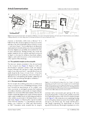
Figure 3. Local sanctuaries in Ugarit. (A) Sanctuary of Rhytons, city center. (B) The New Sanctuary, old royal zone. (C) Royal Sanctuary, new royal zone.
Images produced by the author using AutoCAD software and based on the author’s fieldwork in 2013
character as landmarks visible from a distance. It is A
16
believed that they served as significant beacons for sailors
arriving at the port of Mahadou (Minet el-Beida), located
< 1 km west of Ugarit. On the other hand, the discovered
15
sanctuaries had a more local character; they accommodated
everyday religious and, probably, social activities for civic
or royal communities. Moving forward, this article will
analyze examples of main temples and local sanctuaries
in Ugarit to articulate the influence of political, cultural,
religious, and social dimensions on the architectural and
urban aspects of these buildings.
2.1. The symbolic temples on the acropolis
The two main temples excavated in the city are located
in the Acropolis area (Figure 4). Based on Callot and
Monchambert’s systematic surveys of the two temples,
between 1988 and 1990, and again in 2005, along with the
study of some discovered texts – especially the poems and
myths found in the House of Great Priest – it has been
highlighted that the Acropolis area, with its two temples, is B
important for understanding this ancient civilization and
the city’s urban morphology throughout its lifetime. 15
2.1.1. The main temple of Baal
Figure 4. The morphological settings of the City of Ugarit. (A) Ugarit’s
The two temples show striking similarities in architectural topography showing the location of the Acropolis and its morphological
design, arrangement, form, and building techniques, which settings. (B) The general section of Ugarit showing the city’s topography
have informed the interpretation of the temples’ ruins and the morphological settings of the Acropolis area. Drawings prepared
by the author using AutoCAD software based on topographic information
where excavation or prolonged exposure had destroyed and the author’s filed analysis and observation in 2013.
the evidence; therefore, in this article, the Temple of Baal is
analyzed as a case study of the main temples in the city. The enclosure had a monumental gate opening to the west,
temple occupies the highest point where all routes end; its facing the Royal Palace. A direct street probably connected
ruins occupy a fortified island yet fully integrated with the the temple with the palace, with 70% of this street excavated
urban context, as can be seen in the layout of stairs, ramps, so far (Figure 5). This connection is not surprising, bearing
and streets (Figure 2). Following the original excavation in mind the palace-temple economy that existed in Ugarit
(1929–1932) by Schaeffer, 11,13 a comprehensive systematic during the Late Bronze Age. The temple and the palace
analysis was conducted by Callot and Monchambert had equally empowered the development of various
in 1988. Excavation works revealed that the temple’s aspects of life in the city. The temple’s important role in the
15
Volume 2 Issue 4 (2024) 4 doi: 10.36922/ac.3132