
Page 20 - JCAU-6-1
P. 20
Journal of Chinese
Architecture and Urbanism Spatial exploration through image semantic segmentation
2.2. Overview of semantic segmentation’s several applications in construction personnel management,
applications in urban spaces edge protection safety management, and construction site
Semantic segmentation finds extensive applications in image vehicle management are rooted in computer vision (Gao
processing, holding wide-ranging potential applications in et al., 2022; Gerhard et al., 2018; Zhang et al., 2021).
urban spaces. Common fields of application encompass urban 2.3. Data collection and pre-processing
planning, traffic management, environmental monitoring,
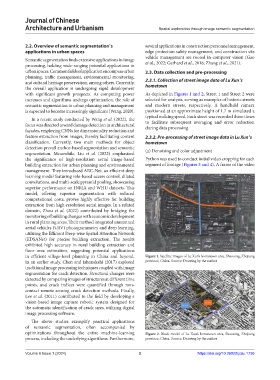
and cultural heritage preservation, among others. Currently, 2.3.1. Collection of street image data of Lu Xun’s
the overall application is undergoing rapid development hometown
with significant growth prospects. As computing power As depicted in Figures 1 and 2, Street 1 and Street 2 were
increases and algorithms undergo optimization, the role of selected for analysis, serving as examples of historic streets
semantic segmentation in urban planning and management and modern streets, respectively. A handheld camera
is expected to become increasingly significant (Wang, 2020). positioned at an approximate height of 1.7 m simulated a
typical walking speed. Each street was recorded three times
In a recent study conducted by Wang et al. (2022), the
focus was directed toward damage detection in architectural to facilitate subsequent averaging and error reduction
during data processing.
façades, employing CNNs for dimensionality reduction and
feature extraction from images, thereby facilitating content 2.3.2. Pre-processing of street image data in Lu Xun’s
classification. Currently, two main methods for object hometown
detection prevail anchor-based segmentation and semantic
segmentation. Meanwhile, Liu et al. (2022) emphasized (a) Denoising and color adjustment
the significance of high-resolution aerial image-based Python was used to conduct initial video cropping for each
building extraction for urban planning and environmental segment of footage (Figures 3 and 4). A frame of the video
management. They introduced ARC-Net, an efficient deep
learning model featuring role-based access control, dilated
convolutions, and multi-scale pyramid pooling, showcasing
superior performance on INRIA and WHU datasets. This
model, offering superior segmentation with reduced
computational costs, proves highly effective for building
extraction from high-resolution aerial images. In a related
domain, Zhou et al. (2022) contributed by bridging the
monitoring of building changes with economic development
in rural planning areas. Their method integrated unmanned
aerial vehicles (UAV) photogrammetry and deep learning,
utilizing the Efficient Deep-wise Spatial Attention Network
(EDSANet) for precise building extraction. The results
exhibited high accuracy in rural building extraction and
floor area estimation, suggesting potential applications
in efficient village-level planning in China and beyond. Figure 1. Satellite images of Lu Xun’s hometown area, Shaoxing, Zhejiang
In an earlier study, Chen and Jahanshahi (2017) explored province, China. Source: Drawing by the author
traditional image processing techniques coupled with image
segmentation for crack detection. Structural changes were
detected by comparing images of structures at different time
points, and crack indices were quantified through non-
contact remote sensing crack detection methods. Finally,
Lee et al. (2011) contributed to the field by developing a
vision-based image capture robotic system designed for
the automatic identification of crack sizes, utilizing digital
image processing software.
The above studies exemplify practical applications
of semantic segmentation, often accompanied by
optimizations throughout the entire machine-learning Figure 2. Block model of Lu Xun’s hometown area, Shaoxing, Zhejiang
process, including the underlying algorithms. Furthermore, province, China. Source: Drawing by the author
Volume 6 Issue 1 (2024) 3 https://doi.org/10.36922/jcau.1736