
Page 28 - JCAU-6-1
P. 28
Journal of Chinese
Architecture and Urbanism Spatial exploration through image semantic segmentation
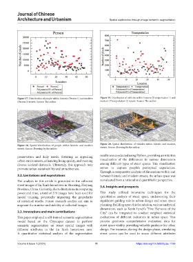
Figure 17. Distribution of people within historic (Person 1) and modern Figure 19. Distribution of vehicles within historic (Transportation 1) and
(Person 2) streets. Source: The author modern (Transportation 2) streets. Source: The author
Figure 20. Spatial distribution of vehicles within historic and modern
Figure 18. Spatial distribution of people within historic and modern streets. Source: Drawing by the author
streets. Source: Drawing by the author
preservation and daily needs, fostering an appealing results was conducted using Python, providing an intuitive
urban environment, enhancing living quality, and meeting visualization of the differences in various dimensions
diverse societal demands. Ultimately, this approach may among different types of street spaces. This visualization
promote urban sustainability and attractiveness. serves to capture people’s perceptual experiences.
Through a comparative analysis of dimensions within and
3.2. Limitations and expectations between historic and modern streets, the urban space was
The analysis in this article is grounded in the collected reevaluated from a rational and quantifiable perspective.
street images of Lu Xun’s hometown in Shaoxing, Zhejiang 3.4. Insights and prospects
Province, China. Currently, due to limitations in computing
power and time, a total of 279 images have been used for This study utilized innovative techniques for the
model training, potentially impacting the granularity quantitative analysis of street space, underscoring their
of statistical results. Future research studies can aim to significant guiding role in urban design and street space
augment the number and stability of collected images. planning. Building upon this foundation, various analytical
dimensions, such as Kevin Lynch’s “Five Elements of the
3.3. Innovations and main contributions City,” can be integrated to conduct weighted statistical
This paper employed a self-trained semantic segmentation evaluations of different indicators in urban space. This
model based on the Cityscapes dataset to perform process generates comprehensive evaluation data for
semantic segmentation on street spatial images with street space vitality, providing valuable guidance for urban
different attributes in the Lu Xun’s hometown area. design. For instance, during the design phase, simulating
A quantitative statistical analysis of the segmentation street scenes can be used to assess different attributes
Volume 6 Issue 1 (2024) 11 https://doi.org/10.36922/jcau.1736