
Page 60 - AJWEP-v22i2
P. 60
Al-Tamimi, et al.
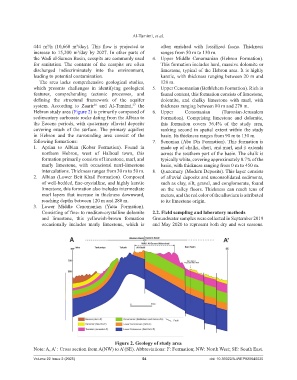
444 m³/h (10,660 m³/day). This flow is projected to often enriched with fossilized fauna. Thickness
increase to 15,200 m³/day by 2027. In other parts of ranges from 50 m to 130 m.
the Wadi al-Samen Basin, cesspits are commonly used 4. Upper Middle Cenomanian (Hebron Formation).
for sanitation. The contents of the cesspits are often This formation includes hard, massive dolomite or
discharged indiscriminately into the environment, limestone, typical of the Hebron area. It is highly
leading to potential contamination. karstic, with thickness ranging between 20 m and
The area lacks comprehensive geological studies, 120 m.
which presents challenges in identifying geological 5. Upper Cenomanian (Bethlehem Formation). Rich in
features, comprehending tectonic processes, and faunal content, this formation consists of limestone,
defining the structural framework of the aquifer dolomite, and chalky limestone with marl, with
system. According to Zaarir and Al-Tamimi, the thickness ranging between 80 m and 270 m.
36
37
Hebron study area (Figure 2) is primarily composed of 6. Upper Cenomanian (Turonian-Jerusalem
sedimentary carbonate rocks dating from the Albian to Formation). Comprising limestone and dolomite,
the Eocene periods, with quaternary alluvial deposits this formation covers 36.4% of the study area,
covering much of the surface. The primary aquifers ranking second in spatial extent within the study
in Hebron and the surrounding area consist of the basin. Its thickness ranges from 90 m to 130 m.
following formations: 7. Senonian (Abu Dis Formation). This formation is
1. Aptian to Albian (Kobar Formation). Found in made up of chalks, chert, and marl, and it extends
northern Hebron, west of Halhoul town, this across the southern part of the basin. The chalk is
formation primarily consists of limestone, marl, and typically white, covering approximately 0.7% of the
marly limestone, with occasional marl-limestone basin, with thickness ranging from 0 m to 450 m.
intercalations. Thickness ranges from 30 m to 50 m. 8. Quaternary (Modern Deposits). This layer consists
2. Albian (Lower Beit Khail Formation). Composed of alluvial deposits and unconsolidated sediments,
of well-bedded, fine-crystalline, and highly karstic such as clay, silt, gravel, and conglomerate, found
limestone, this formation also includes intermediate on the valley floors. Thickness can reach tens of
marl layers that increase in thickness downward, meters, and the red color of the alluvium is attributed
reaching depths between 120 m and 280 m. to its limestone origin.
3. Lower Middle Cenomanian (Yatta Formation).
Consisting of fine- to medium-crystalline dolomite 2.2. Field sampling and laboratory methods
and limestone, this yellowish-brown formation Groundwater samples were collected in September 2019
occasionally includes marly limestone, which is and May 2020 to represent both dry and wet seasons.
Figure 2. Geology of study area
Note: A, A’ : Cross section from A(NW) to A’(SE). Abbreviations: F: Formation; NW: North West; SE: South East.
Volume 22 Issue 2 (2025) 54 doi: 10.36922/AJWEP025040020