
Page 38 - JCAU-6-2
P. 38
Journal of Chinese
Architecture and Urbanism Regenerating tradition: Rural revitalization
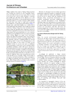
Village residents. The people of Yulong Village maintain However, the dominant trend in modern agricultural
their worship and reverence for the mountains, forests, development, primarily focused on quantitative growth,
rivers, and land. In front of every house, there is a small has largely eroded the beliefs and traditional farming
shrine where the Li family make offerings to mountain practices of the Li family. With the damming of the
god, earthly god, and other deities. Shanlan rice is still Changhua River, uncontrolled development of land
venerated; at the borders of some uncultivated mountains resources, modernized agriculture emphasizing cash
and paddy fields, the Li people continue to plant Shanlan crops, near-total abandonment of the “Kanshanlan”
rice and other local crops in small areas, preserving cultivation, large-scale deforestation of mountain forests,
other traditions of crop planting and rotation (Figure 7). and the loss of animal habitats, the spatial opportunities
Shanlan wine, made from Shanlan rice, is still served at for Yulong Village residents to maintain their traditional
family gatherings and banquets. Even though the current activities and associations with flora and fauna are
residents of Yulong Village have been relocated at some becoming insignificant. Yet their knowledge systems may
distance from the ancestral forest cemeteries, modern Li prove beneficial as global climates warm and biodiversity
family have adapted forest areas near where their relocated loss affects sustainability.
village meets their agricultural fields as a new cemetery,
maintaining trees and plants in that area as lush as possible. 2.2. Green infrastructure design tools for Yulong
While Yulong villagers no longer build boat-shaped Village
houses, they still use local bamboo, rattan, hemp, and grass While the current environmental degradation is
plants to build fences, barriers, and storage shelters. They widespread, the future impact of intensified rainstorms
also maintain traditions of gathering plants for weaving and typhoons resulting from climate change poses an
and dyeing cloth. Li women from all generations in the additional threat to the lives and landscapes of Yulong
village often gather in their yards or in front of their Village residents. This scenario anticipates an increase
neighbors’ houses to practice and pass on traditional in flooding, landslides, and crop damage. Considering
weaving techniques. In the yards, areas for storing modern that the Li people have navigated changes and natural
agricultural machinery coexist with spaces reserved for events for nearly 2000 years, there is likely value in
growing local plants for home consumption and medicinal exploring how to cultivate the regeneration of ecology
purposes. On the riverbanks, Li residents of Yulong Village – a green infrastructure based on Li family’s agricultural
still spontaneously gather to dig their own ditches, guided
by the topography and the direction of water flow to secure values.
water for irrigation. Every year, during the rise in water Accordingly, we undertook a design research
levels that floods the riverbanks, village children play in investigation of green infrastructure in the environment of
the shallows and fish from the shore. Older Li teenagers in Yulong Village. The aim of the green infrastructure design
the village are proficient swimmers and skilled in rowing is to spatialize the potential for ecological adaptability
boats, which villagers still use to transport tools, materials, to extreme weather, improve ecosystem health, restore
and agricultural commodities (Figure 8). species diversity, and continue traditional Li family’s
agricultural autonomy. In regional settings in China,
green infrastructure is primarily based on morphological
spatial pattern analysis and multivariate curve resolution
analysis tools. However, the limited accuracy of available
data and the broad acreage of Yulong Village’s fields make
these tools inadequate for coping with design at a relatively
detailed scale. To address this, our project used other tools
to elucidate on morphological possibilities of beneficial
hydrology, community, and vegetation systems. Hence, our
approach integrated existing satellite images, field surveys,
Rhino 3D modeling, and McHarg’s “layer-cake” land
suitability analysis.
We imported the topographic features of the site,
recording them during the field survey and utilizing the
clipped digital elevation modeling grid files. Subsequently,
Figure 7. Li traditional farm practice in Yulong village. Source: On-site we used Rhino 3D modeling to depict the topography of
photos by the authors the site and Grasshopper’s Stormwater Runoff Analysis
Volume 6 Issue 2 (2024) 8 https://doi.org/10.36922/jcau.1304