
Page 40 - JCAU-6-2
P. 40
Journal of Chinese
Architecture and Urbanism Regenerating tradition: Rural revitalization
Guided by field surveys and an understanding of 3. Results
the significance of oral narratives, the design mapped
the daily circulation pathways of the local Li people 3.1. Empowering Li family’s agriculture through
and analyzed the spatial expression of Li family’s green infrastructure in Yulong Village
traditional belief systems. Leveraging satellite images The proposed green infrastructure network, consisting
to discern patterns of forest and shrub vegetation in of water corridor and vegetation corridor systems, aims
the mountains, farmland, and village surroundings, to improve the resilience of Yulong Village to weather
we proposed vegetation corridors. These mappings extremes, will reshape residents’ ability to connect with
were then superimposed onto the general shaping of nature, and provide space for the revitalization of traditional
water corridors to ensure that the morphology of the Li family’s agricultural activities. The design research
vegetation corridors fully covered the existing daily shows how these goals can be achieved (Figure 11).
collection and ritual activities of the Yulong Village The Li village-based water corridor system in the
residents (Figure 10). To respect the living traditions of mountain would serve to divert runoff from the slopes
Yulong Villagers and avoid unnecessary disturbances, during heavy rains, preventing flood damage to the
the fieldwork extended green infrastructure to a detailed village and fields. In addition, it would collect rainwater
scale within the village. Utilizing humble concrete during the dry season, providing irrigation for planting
drainage channels, the design incorporated a landscape and sustaining the organisms in the vegetation corridors.
strip of graminoid plants to facilitate rainwater Within the native amphibian-populated vegetation
infiltration and minimize the impact on village life. corridor system, species such as frogs and birds would
This approach in design research combined site-based
interpretations with modern cartographic technologies, contribute to controlling locusts (Figure 12).
seamlessly integrating broader vegetation patches and Along the river’s edge, mangrove shallows would provide
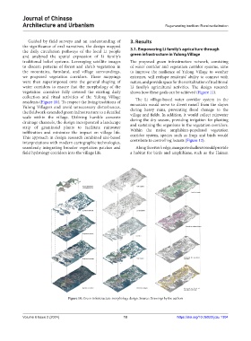
field hydrology corridors into the village life. a habitat for birds and amphibians, such as the Hainan
Figure 10. Green infrastructure morphology design. Source: Drawings by the authors
Volume 6 Issue 2 (2024) 10 https://doi.org/10.36922/jcau.1304