
Page 107 - JCAU-7-1
P. 107
Journal of Chinese
Architecture and Urbanism Spatial evolution of Fuzhou and Xiamen ports
A
B
C
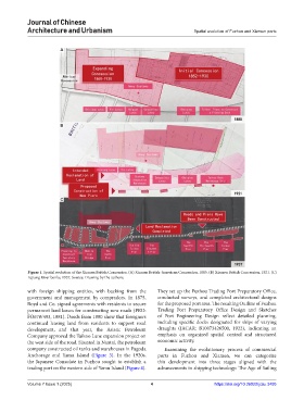
Figure 1. Spatial evolution of the Xiamen British Concession. (A) Xiamen British-American Concession, 1885. (B) Xiamen British Concession, 1921. (C)
Lujiang River banks, 1937. Source: Drawing by the authors.
with foreign shipping entities, with backing from the They set up the Fuzhou Trading Port Preparatory Office,
government and management by compradors. In 1875, conducted surveys, and completed architectural designs
Boyd and Co. signed agreements with residents to secure for the proposed port area. The resulting Outline of Fuzhou
permanent land leases for constructing new roads (PRO: Trading Port Preparatory Office Design and Sketches
FO678/493, 1881). Deeds from 1880 show that foreigners of Port Engineering Design reflect detailed planning,
continued leasing land from residents to support road including specific docks designated for ships of varying
development, and that year, the Asiatic Petroleum draughts (JACAR: B10073426500, 1922), indicating an
Company approved the Taikoo Lane expansion project on emphasis on organized spatial control and structured
the west side of the road. Situated in Nantai, the petroleum economic activity.
company constructed oil tanks and warehouses in Pagoda Examining the evolutionary process of commercial
Anchorage and Yamu Island (Figure 3). In the 1920s, ports in Fuzhou and Xiamen, we can categorize
the Japanese Consulate in Fuzhou sought to establish a this development into three stages aligned with the
trading port on the western side of Yamu Island (Figure 4). advancements in shipping technology: The Age of Sailing
Volume 7 Issue 1 (2025) 4 https://doi.org/10.36922/jcau.3495