
Page 42 - AC-2-3
P. 42
Arts & Communication Leonardo from Caffa in Crimea
promontory was relatively easy to find by studying images detail that Italian researchers have been unable to resolve.
of the region. The depiction matches a port called Sudak, Indeed, the conical hill in the distance is approximately at
50 km south-west of Caffa, that was also under Genoese the same elevation, which is therefore also around 150 m
control. What Nicholl calls a wide waterlogged flatland is, (contradicting the suggestion that it is Monsummano,
in reality, the depiction of bay, full of boats as if a siege which is a peak at an elevation of 330 m). The mountains
or battle is taking place. Stretching away toward the that are depicted in the drawing rising behind this hill are
mountains on the horizon are wheat fields, for which then around two to three times this height, which is also
Crimea is renowned. The fortress at Sudak (Figure 3) is now accurate to the topography of Sudak. Notably, Sudak was
17
a World Heritage Site and was under Genoese control for taken over by the Genoese in 1381, who constructed the
200 years until 1475. However, the “waterfall” proved to be fortress over many decades in the early 14 century. “The
th
somewhat tricky. In the past, I was misled by the insistence fortress area was 29.5 ha; the total length of the surrounding
of Italian experts that the rocky depiction to the right of walls was about 1000 m. The height of the towers reached
the drawing represents a permanent waterfall and that 15 m, the height of the walls was 6 m, reaching in some
this drawing is a pastiche of elements of topography many places to 8 m, and the wall thickness was 1.5 – 2 m”. 18,p.295
miles apart. I identified a waterfall south of Sudak, near Much of the fortress remains standing.
the port of Yalta (or, in Genoese times, Italita). I proposed
that the artist pastiched the Uchan-su Waterfalls into On the highest pinnacle of the fortress are the ruins of a
his depiction of Sudak. However, I was wrong. Further lookout point, the Maiden Tower. I postulate that there was
16
research revealed that this drawing, although constructed a cistern to collect rainwater for the guards. If this cistern
from existing sketches, a point proposed by Frosinini, 9,p.246 overflowed, it would indeed run down the side of the cliff,
is, in fact, a single vantage point. The key to understanding resembling a waterfall. Archaeologists have discovered that
this landscape is the “waterfall,” which I now propose must the Genoese made extreme efforts to ensure the fortress
19
have been ephemeral, an intermittent flow of water caused had fresh water in cisterns and underground tanks.
by phenomena other than a river falling over a cliff. I believe that it is such an ephemeral waterfall that the
draughtsman of the landscape 8P is depicting. This feature,
Although it is currently impossible to visit Crimea
because of security issues, nevertheless, as the fortress
at Sudak is a World Heritage Site, there are thousands of
photographs on the internet. I was able to determine the
draughtsman’s vantage point in 8P, if this is a depiction of
Sudak as I postulate, without having access to the exact
place where he might have been sitting, particularly as
the fortress on the promontory is the most convenient
landmark (Figures 4 and 5). Sudak sits on a small bay at the Figure 4. Left panel: View of Sudak from the fortress close to the Maiden
very northern reaches of the Crimean Mountains, which Tower. Right panel: Zooming on a detail of the distant mountains,
range from Balaklava in the south, stretching approximately showing a tump-shaped hill slightly off to the right of the eye-line as it
200 km. The topmost point of the natural rocky cliff barrier follows the rampart wall. Retrieved from Wikimedia Commons, February
on the seafront, where the fort is situated, is 158 m. This 17, 2024. Author: Деревягін Ігор, 2013; https://commons.wikimedia.
puts the draughtsman of 8P at about that height, a specific org/wiki/File:Архітектурно-археологічний_комплекс-Судацька_
фортеця_%3D%3D%3D.jpg in the public domain.
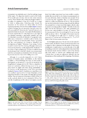
Figure 3. An aerial view of the Genoese Fortress at Sudak, Victoria Figure 5. View of Sudak from the Genoese Fortress. Retrieved from
Koltsova. License free. Retrieved from vecteezy_aerial-view-of-the- https://en.m.wikipedia.org/wiki/File: View_of_Sudak_from_Genoese_
mountain-landscape-with-the-genoese_3051685.jpg 17 February 2024. Fortress.jpg, February 17, 2024, in the public domain.
Volume 2 Issue 3 (2024) 5 doi: 10.36922/ac.2642