
Page 122 - AC-3-2
P. 122
Arts & Communication Constructing the image of ancient cities
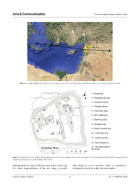
Figure 1. Google Map illustrates the location of Ugarit, sourced from Google Map with author analysis on it using Photoshop software
Figure 2. The plan of the city of Ugarit shows the location of the main temples and the local sanctuaries in the city, produced by the author using AutoCAD
software and based on the author’s fieldwork in 2013
and intangible heritage at different scales and to connecting and consistent overall narrative which is considered a
the urban fragmentations of the city using a sensible substantial contribution that this work makes.
Volume 3 Issue 2 (2025) 3 doi: 10.36922/ac.4239