
Page 126 - AC-3-2
P. 126
Arts & Communication Constructing the image of ancient cities
A B
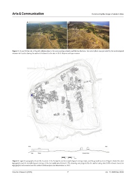
Figure 3. (A and B)The city of Ugarit’s relationships to the surrounding suburbs and the two harbors. The aerial photo was provided by the archeological
museum in Latakia during the author’s fieldwork to the site in 2013. Reprint with permission
Figure 4. Ugarit’s topography shows the location of the Acropolis and its morphological settings (top), and the general section of Ugarit shows the city’s
topography and the morphological settings of the Acropolis area (bottom). The drawing was prepared by the author using AutoCAD software based on
topographic information and the author’s field analysis and observation in 2013
Volume 3 Issue 2 (2025) 7 doi: 10.36922/ac.4239