
Page 128 - AC-3-2
P. 128
Arts & Communication Constructing the image of ancient cities
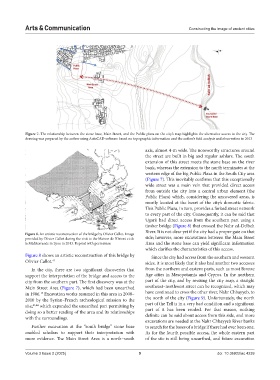
Figure 7. The relationship between the stone base, Main Street, and the Public plaza on the city’s map highlights the alternative access to the city. The
drawing was prepared by the author using AutoCAD software based on topographic information and the author’s field analysis and observation in 2013
axis, almost 4-m wide. The noteworthy structures around
the street are built in big and regular ashlars. The south
extension of this street meets the stone base on the river
bank, whereas the extension to the north terminates at the
western edge of the big Public Plaza in the South City area
(Figure 7). This inevitably confirms that this exceptionally
wide street was a main vein that provided direct access
from outside the city into a central urban element (the
Public Plaza) which, considering the uncovered areas, is
mostly located at the heart of the city’s domestic fabric.
This Public Plaza, in turn, provides a forked street network
to every part of the city. Consequently, it can be said that
Ugarit had direct access from the southern part using a
timber bridge (Figure 8) that crossed the Nahr ed-Delbeh
River. It is not clear yet if the city had a proper gate on that
Figure 8. An artistic reconstruction of the bridge by Olivier Callot. Image
provided by Olivier Callot during the visit to the Maison de l’Orient et de side; however, more excavations between the Main Street
la Méditerranée in Lyon in 2013. Reprint with permission Area and the stone base can yield significant information
which clarifies the characteristics of this access.
Figure 8 shows an artistic reconstruction of this bridge by Since the city had access from the southern and western
Olivier Callot. 41 sides, it is most likely that it also had another two accesses
In the city, there are two significant discoveries that from the northern and eastern parts, such as most Bronze
support the interpretation of the bridge and access to the Age cities in Mesopotamia and Cyprus. In the northern
city from the southern part. The first discovery was at the part of the city, and by revising the city map, a straight
Main Street Area (Figure 7), which had been unearthed southeast–northwest street can be recognized, which may
in 1986. Excavation works resumed in this area in 2008– have continued to cross the other river, Nahr Chbayyeb, to
18
2010 by the Syrian–French archeological mission to the the north of the city (Figure 9). Unfortunately, the north
site, 43,44 which expanded the unearthed part permitting by part of the Tell is in a very bad condition and a significant
doing so a better reading of the area and its relationships part of it has been eroded. For that reason, nothing
with the surroundings. definite can be said about access from this side, and more
excavations are needed at the Nahr Chbayyeb River banks
Further excavation at the “south bridge” stone base to search for the bases of a bridge if there had ever been one.
enabled scholars to support their interpretation with As for the fourth possible access, the whole eastern part
more evidence. The Main Street Area is a north–south of the site is still being unearthed, and future excavation
Volume 3 Issue 2 (2025) 9 doi: 10.36922/ac.4239