
Page 133 - AC-3-2
P. 133
Arts & Communication Constructing the image of ancient cities
built using large ashlar stones on the corners and rubble
walls in between. The stone construction is supported with
timber frames to make the walls and create the ceilings
and roofs. The planning and construction technologies,
55
which have a striking similarity to the architecture of
Ancient Thera in Santorini, Greece, highlight the influence
of the Royal Area, as a new urban artifact, on the city’s
development. This development gradually decreased
toward the east, reaching the Acropolis area and Lower
City, where people kept their original houses but adopted
the new architectural approaches and techniques as much
as they could afford. Thus, the existence of the Royal Palace
was quite significant not only for the development of the
city’s political, administrative, and economic systems
but also for the development of its urban structure and
architectural quality.
The earthquake, which hit the city during the
th
13 century BC (most probably in 1250 BC), 38,57 was
another key event in Ugarit’s history that contributed to
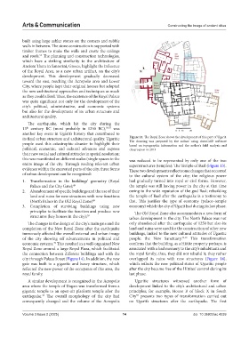
its final urban structure and architectural quality. Ugaritic Figure 14. The Royal Zone shows the development of this part of Ugarit.
The drawing was prepared by the author using AutoCAD software
people used this catastrophic disaster to highlight their based on topographic information and the author’s field analysis and
political, economic, and cultural advances and express observation in 2013
their new social and cultural attitudes in spatial resolution;
this was manifested on different scales (single spaces to the was reduced to be represented by only one of the two
entire image of the city. Through reading relevant urban superstructures (temples): The Temple of Baal (Figure 13).
evidence within the excavated parts of the city, three forms These two developments reflect some changes that occurred
of urban development can be recognized: to the cultural system of the city; the religious power
1. Transformation in the buildings’ geometry (Royal had gradually turned into royal or civil forms. However,
Palace and the City Gate); 49 the temple was still having power in the city at that time
2. Abandonment of specific buildings and the use of their owing to the wide reputation of the god Baal; rebuilding
land and ruins for new structures with new functions the temple of Baal after the earthquake is a testimony to
(North Palace in the Old Royal Zone) 49 that. This justifies the type of economy (palace–temple
3. Completion of surviving buildings using new economy) which the city of Ugarit had during its last phase.
principles to facilitate the function and produce new The Old Royal Zone also accommodates a new form of
structures (key houses in the city); 55 urban development in the city. The North Palace was not
The changes in the design of the city’s main gate and the only abandoned after the earthquake of 1250 but also its
completion of the New Royal Zone after the earthquake land and ruins were used for the construction of other new
immensely affected the overall external and urban image buildings, linked to the new cultural attitudes of Ugaritic
of the city showing off advancements in political and people: the New Sanctuary. 45,49 This transformation
economic systems. This resulted in a well-organized New confirms that the building, as a Hittite property perhaps, is
49
Royal Zone around a large Royal Plaza, which facilitated associated with a bad memory to the city’s inhabitants and
the connection between different buildings and with the the royal family; thus, they did not rebuild it; they rather
city through Palace Street (Figure 14). In addition, the new overlapped its ruins with new structures (Figure 14),
gate was built in a gigantic and heavy structure, which which reflects the new political status of Ugaritic people
reflected the new power of the occupants of this area, the after the city became free of the Hittites’ control during its
royal family. last phase.
A similar development is recognized in the Acropolis Ugaritic structures witnessed another form of
area where the temple of Dagan was transformed from a development linked to the city’s architectural and urban
gigantic temple to an open-air platform temple after the principles; for example, House B of block X in South
earthquake. The overall morphology of the city had City presents two types of transformation carried out
55
46
consequently changed and the volume of the Acropolis on Ugarit’s structures after the earthquake. The first
Volume 3 Issue 2 (2025) 14 doi: 10.36922/ac.4239