
Page 138 - AC-3-2
P. 138
Arts & Communication Constructing the image of ancient cities
A B C
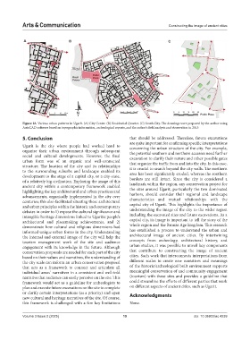
Figure 18. Various urban patterns in Ugarit. (A) City Center. (B) Residential Quarter. (C) South City. The drawings were prepared by the author using
AutoCAD software based on topographic information, archeological reports, and the author’s field analysis and observation in 2013
5. Conclusion that should be addressed. Therefore, future excavations
are quite important for confirming specific interpretations
Ugarit is the city where people had worked hard to concerning the urban structure of the city. For example,
organise their urban environment through subsequent the potential southern and northern accesses need further
social and cultural developments. However, the final excavation to clarify their nature and other possible gates
urban form was of an organic and well-connected that organize the traffic from and into the city. In this case,
structure. The location of the city and its relationships it is crucial to search beyond the city walls. The northern
to the surrounding suburbs and landscape enabled its area has been significantly eroded, whereas the southern
development to the stage of a capital city, or a city-state, borders are still intact. Since the city is considered a
of a relatively big civilisation. Exploring the image of this landmark within the region, any conservation project for
ancient city within a contemporary framework enabled the sites around Ugarit, particularly the two dominated
highlighting the key architectural and urban practices and
advancements, organically implemented in the city over harbors, should consider their regional and landscape
centuries; this also facilitated situating these architectural characteristics and mutual relationships with the
and urban principles within the historic and contemporary capital city of Ugarit. This highlights the importance of
debates in order to 1) expose the cultural significance and understanding the image of the city to the wider region
intangible heritage dimensions linked to Ugaritic people’s including the excavated sites and future excavations. As a
architectural and placemaking achievements, and 2) capital city, its image is important to tell the story of the
demonstrate how cultural and religious dimensions had whole region and the Bronze Age kingdom. This research
informed unique urban forms in the city. Understanding has established a process to understand the urban and
the internal and external image of the city will help the architectural image of ancient cities. By intertwining
tourism management work of the site and audience concepts from archeology, architectural history, and
engagement with its knowledge in the future. Although urban studies, it was possible to unveil key components
conservation proposals are needed for each part of the city that contribute to constructing the image of ancient
based on their values and narratives, the understanding of cities. Such work that interconnects interpretations from
the city scale can inform an urban conservation proposal different scales to create new narratives and meanings
that acts as a framework to connect and articulate all of the historic/archeological built environment supports
individual areas’ narratives in a consistent and well-told meaningful conservation of and community engagement
narrative that audience can easily perceive on the site. This (tourism) with these sites and provides a guideline that
framework would act as a guideline for archeologists to could streamline the efforts of different parties that work
plan and execute future excavations on the site to complete on different aspects of ancient cities, such as Ugarit.
or clarify certain interpretations (as a priority) and open Acknowledgments
new cultural and heritage narratives of the site. Of course,
this framework is challenged with a few key limitations None.
Volume 3 Issue 2 (2025) 19 doi: 10.36922/ac.4239