
Page 134 - AC-3-2
P. 134
Arts & Communication Constructing the image of ancient cities
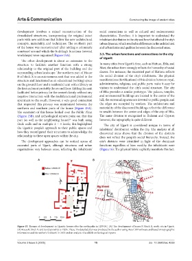
development involves a mixed reconstruction of the social connections as well as cultural and socioeconomic
demolished structures, incorporating the original intact characteristics. Therefore, it is important to understand the
parts with new additions that follow the new architectural inhabitant distribution in the city and how that affected the city’s
concepts, materiality, and techniques. The southern part urban dynamic, which resulted in differences in the architectural
of the house was reconstructed after adding a colonnade and urban forms and qualities between the discovered areas.
courtyard around which the building’s functions (several
workshops) were organized (Figure 15A). 3.3. The urban functions and connections in the city
of Ugarit
The other development is about an extension to the
structure to facilitate another function with a strong In many cities from Ugarit’s time, such as Hattusa, Ebla, and
relationship to the original part of the building and the Mari, the urban form strongly reflects the hierarchy of social
surrounding urban landscape. The northern part of House classes. For instance, the excavated part of Hattusa reflects
B of block X is an autonomous unit that was added to the the social division of the city’s inhabitants. The physical
structure and functioned as an educational (writing) space manifestations (fortifications) of this division between royal,
on the ground floor and a residential unit with a library on administrative, religious, and public parts make it easy for
the first and most probably the second floor. Adding this unit visitors to understand the city’s social structure. The city
facilitated better privacy for the owner’s family without any of Ebla provides a similar prototype. The palaces, temples,
negative interaction with the multifunctional professional and monumental buildings are located in the center of the
apartment to the south. However, a very good connection hill, the surrounding areas are devoted to public people, and
that respected this privacy was maintained between the the edges are occupied by workers. The architecture and
northern and southern parts of the house (Figure 15A). materiality of the discovered buildings reflect the difference
The extension of this house looked over the Public Plaza in wealth between the center and edges of the city of Ebla.
(Figure 15B), and archeological reports point out that this The same division is recognized in Enkomi and Cyprus;
55
part (as well as the neighboring house) was built using however, the topography is quite different.
thick walls and in multiple 2 – 3 levels; this highlighted The city of Ugarit is considered unique in terms of
the Ugaritic people’s approach to their public spaces and inhabitant’ distribution within the city. The analysis of all
how they reconfigured their structures to acknowledge the discovered areas shows that the division of the districts
relationship to these open spaces within the city. does not reflect the people’s social hierarchy. Instead, the
The development approaches can be noticed across all city’s districts were identified in light of the dominant
excavated parts of Ugarit, although structures and urban functions regardless of how wealthy the inhabitants were
organizations vary between areas, reflecting the inhabitants’ (Figure 16). The physical fabric explicitly manifests this fact.
A B
Figure 15. Themes of development in Ugaritic houses after the earthquake in 1250 BC. (A) The development of house B, block X, south city in Ugarit.
(B) House B, block X, and its relationship to Public Plaza. The detailed plan was produced by the author using AutoCAD software and based on topographic
information and the author’s fieldwork in 2013 and an analysis of available archeological reports
Volume 3 Issue 2 (2025) 15 doi: 10.36922/ac.4239