
Page 129 - AC-3-2
P. 129
Arts & Communication Constructing the image of ancient cities
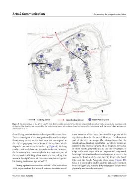
Figure 9. The general map of the city of Ugarit’s plan shows possible accesses to the city and primary and secondary public spaces in the excavated parts
of the city. The drawing was prepared by the author using AutoCAD software based on topographic information and the author’s field analysis and
observation in 2013
should bring new information about possible access there. street structure of the city as there is still a huge part of the
The excavated part of the Acropolis and its southern slope city that needs to be discovered. However, the discovered
shows many streets which head east and correspond to part of the city encourages the interpretation that the
the city’s topography. One of them is Library Street which overall urban structure constitutes ring-streets which are
aligns the two main temples in the city (Figure 9). Nothing parallel to the site’s topography. These rings are connected
can be confirmed about any access from the east; however, by short streets, perpendicular to the site topography, to
the location of the main temples in the northeast part of adapt to the site’s slope. Most of the proposed rings result
the city evokes thinking about eastern access, taking into from logical connections between discovered areas, as is the
account the significance of these two temples to Ugaritic case in the Residential Quarter, the City Center, the South
life during the Bronze Age period. 45,46 City, and the South Acropolis Slope areas (Figure 10).
Thus, it is essential to understand the urban development
During a private conversation with O. Callot in October forms in Ugarit and how the different areas of the city were
2013, he pointed out that he is still not sure about the overall physically and socially connected.
Volume 3 Issue 2 (2025) 10 doi: 10.36922/ac.4239