
Page 132 - AC-3-2
P. 132
Arts & Communication Constructing the image of ancient cities
A B
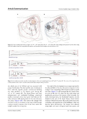
Figure 12. Urban development forms in Ugarit. (A) 19 – 16 century BC; (B) 16 – 13 century BC. The drawings were prepared by the author using
th
th
th
th
AutoCAD software based on topographic information and the author’s field analysis and observation in 2013
th
th
Figure 13. General sections of the city show the development of the city’s morphology between 20 and 13 century BC. The source of the original section
56
is obtained from Oliver Callot and then edited by the author. Reprint with permission
the whole area of the Tell/site and was equipped with The result of this development was strongly expressed in
proper fortification. The city kept the same development the physical fabric of the city; this can be recognized in the
form until the Ugaritic people commenced building changes in the morphology of the Royal Area and Acropolis
the royal facilities in the western part during the over time (Figure 13) and subsequently the overall urban
th
th
16 or 15 century BC. The Royal Palace and other structure of the city; it is clear that the royal power was
administrative and residential buildings constituted significantly growing at the expense of the Acropolis. The
another dominant urban focal point that balanced the newly developed area, the Residential Quarter, directly
urban dynamic with much power for the new structure, situated to the east of the Royal Palace, shows further
the palace (Figure 12B). This reflects the changes that evidence of this development. The architectural materiality,
occurred to the city economy at that time, which became technology, and organization of the buildings in this area
a palace–temple economy after it had been under the manifest great development. The houses were planned
temple’s control for a long time. using larger and more orthogonal and clear spaces, and
Volume 3 Issue 2 (2025) 13 doi: 10.36922/ac.4239