
Page 127 - AC-3-2
P. 127
Arts & Communication Constructing the image of ancient cities
Figure 5. The map shows the location of Ugarit within the Mediterranean trade network. © The National Museum in Latakia provided to the author during
fieldwork to the site in 2013. Reprint with permission
A B
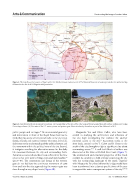
Figure 6. Ugarit’s natural and manmade boundaries. (A) Google Map of the site of the city. Sourced from Google Map with author analysis on it using
th
Photoshop software. (B) The ruins of the 15 -century tower and postern gate. Photo is taken by the author as part of the fieldwork in 2013
public people and carriages. Its monumental geometry Marguerite Yon and Oliver Callot, who have been
38
and termination in front of the Royal Palace lead one to central in studying the architecture and urbanism of
think that this access served special traffic to the city: royal the site, kept investigating the evidence for another
family, officials, and external visitors. This issue, first of all, potential access to the city. Excavation works at the
39
elaborates on the understanding of the political system and river bank, carried out by Y. Calvet and B. Geyer to the
the movement within the political zone of the city. Second, south of the city, brought to light a significant clue about
it instigates searching for alternative access for the daily commuting access. 40,41 A well-built block of ashlars was
life movement between the city and surrounding fields. discovered at the Nahr ed-Delbeh River bank (Figure 7).
Potential access(es) should have been sufficient for the flow The architectural and structural properties of this block
of carts that were used to bring crops and merchandise, confirm its capability to hold a bridge connecting the city
30
(pp.37–47). The constitution and design of the western with the surrounding landscape to the south. Together
gate do not facilitate the continuous movement of carts with Marguerite Yon, they believe this bridge would have
from and into the city; approaching the western gate was been transformed into a dam at specific times of the year
done through a very sloped route (Figure 6B). to support the water management system of the city. 30,40-42
Volume 3 Issue 2 (2025) 8 doi: 10.36922/ac.4239