
Page 130 - AC-3-2
P. 130
Arts & Communication Constructing the image of ancient cities
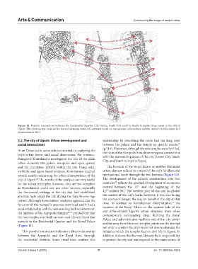
Figure 10. Possible connections between the Residential Quarter, City Center, South City, and the South Acropolis Slope areas in the city of
Ugarit. The drawing was prepared by the author using AutoCAD software based on topographic information and the author’s field analysis and
observation in 2013
3.2. The city of Ugarit: Urban development and relationship by describing the route that the king used
48
social interactions between the palace and the temple in specific events,
(p.219). Moreover, although the two temples were fortified,
At an Urban scale, some scholars worked on analyzing the
city’s urban forms and social dimensions. For instance, the ruins of the Acropolis Area show very good connections
with the surrounding areas of the city (Lower City, South
Panagiotis Kontolaimos investigated the role of the main City, and South Acropolis Slope).
urban elements (the palace, acropolis, and open spaces)
and the circulation pattern within the city. Using axial, The location of the Royal Palace as another dominant
visibility, and agent-based analyses, Kontolaimos reached urban element reflects its control of the city’s (civilization)
several results concerning the urban characteristics of the international trade through the two harbors (Figure 3A).
city of Ugarit. The results of the analyses are very useful The development of the palace’s construction over two
47
49
for the urban principles; however, they are not complete centuries reflects the gradual development of economic
th
as Kontolaimos could not use other sources, especially control between the 15 and the beginning of the
th
the discovered writings in the city that had established 12 century BC. The western part of the city facilitated
absolute facts about the city during the Late Bronze Age the control of the city’s trade; however, it was also facing
period. Although Kontolaimos’ analysis suggested that the the source of danger, the sea, on behalf of the city at that
47
function of the Acropolis area was restricted and it had a time. In contrast to Kontolaimos’ interpretation, the
weak relationship with the surrounding built environment, location of the Royal Palace on the western side of the
the analysis of the Acropolis temples 45,46 pointed out that city differentiated Ugarit’s urban structure from other
the two temples were built on west–east Library Street that contemporary surrounding cities. Building the Royal
extends to the Residential Quarter and the Royal Palace Palace and administrative facilities out of the city center
and far away from the main temples points out the attempt
(Figure 11).
not only to control the city’s trade but also to decrease the
This possible connection indicates a direct relationship influence which the temples had on civil life in Ugarit. In
between the Acropolis and the Royal Area, through addition, it shows that the royal dynasty had a responsibility
the residential districts. Some ritual texts confirm this to protect the city and was exposed to the main source of
Volume 3 Issue 2 (2025) 11 doi: 10.36922/ac.4239