
Page 40 - {PDF Title}
P. 40
Voropaev, et al.
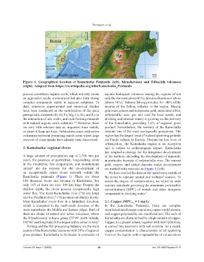
Figure 1. Geographical location of Kamchatka Peninsula (left); Klyuchevskoy and Tolbachik volcanoes
(right). Adopted from https://en.wikipedia.org/wiki/Kamchatka_Peninsula
process constitutes organic acids, which not only create aquatic biological resources among the regions of not
an aggressive acidic environment but also form strong only the Far East (about 45%), but also Russia as a whole
complex compounds stable in aqueous solutions. To (above 30%). Salmon fishing provides 30 – 40% of the
7
date, extensive experimental and numerical studies income of the fishing industry in the region. Mining
have been conducted on the mobilization of the main (platinum, placer and indigenous gold, associated silver,
petrogenetic elements (Si, Al, Fe, Mg, Ca, Na, and K) on polymetallic ores, gas and coal for local needs, and
the interaction of ash, rocks, and rock-forming minerals drinking and mineral water) is growing on the territory
with natural organic acids solutions. However, there of the Kamchatka, providing 5.6% of regional gross
2-4
are very little relevant data on important trace metals, product. Nevertheless, the territory of the Kamchatka
as some of them are toxic. Subduction zones with active remains one of the most ecologically prosperous. The
volcanism represent promising search areas where large region has the largest areas of natural spawning grounds
reserves of some metals have already been discovered. for Pacific salmon in Eurasia. Despite the low level of
urbanization, the Kamchatka region is no exception
2. Kamchatka’ regional rivers and is subject to anthropogenic impact. Kamchatka
has adopted a strategy for the integrated development
A large amount of precipitation (up to 2,700 mm per of the territory, including the development of minerals,
year), the presence of permafrost, long-melting snow in particular deposits of polymetallic ores. The current
in the mountains, low evaporation, and mountainous gold, copper, and nickel deposits under development
terrain are the reasons for the development of are marked with asterisks on Figure 1 (left).
5
an exceptionally dense rivers network within the We have studied the data on the main heavy metals of
Kamchatka peninsula (Figure 1). There are about the rivers to separate natural and technical sources. To
140 thousand rivers and streams in Kamchatka, but assess the degree of contamination, we relied on state
only 105 of them are over 100 km long. Despite the sanitary standards governing the maximum permissible
shallow depth, the rivers possess exceptionally high concentrations (MPC) of metals and other inorganic
water flux. The main Kamchatka river (758 km long) compounds in drinking water. 8
and the Penzhina river (713 km) stand out sharply in size.
Most Kamchatka’ rivers flow in a latitudinal direction, 2.1. Copper (MPC = 1 mg/L)
Cu
which is elongated in the north-south direction of the In the Kamchatka Peninsula, there are complex
main watersheds: the Middle and Eastern ridges. Both of manifestations of copper-copper ore, copper-molybdenum,
them are chains of extinct and active volcanoes, where and copper-polymetallic ore manifestations. The soils of
the Klyuchevskoy volcano group (55°90’ north latitude, Kamchatka are characterized by a high content of copper.
160°60’ east longitude) is the largest active center in Asia. 6 Copper, to a greater extent, together with iron hydroxide,
Fishing and the fish processing industry are the main is carried into reservoirs with soil solution. As a result,
sectors of the Kamchatka’ economy with 20% of regional copper contamination is characteristic of all spawning
gross product. Kamchatka is the leader in extraction of rivers of the region, with a repeatability of values above
Volume 22 Issue 1 (2025) 34 doi: 10.36922/ajwep.8113