
Page 41 - {PDF Title}
P. 41
Weathering on Kamchatka volcanoes
the threshold of 57 – 100%, in which the copper content compounds in the Bersh river during a high water was
exceeded the MPC by 1.5 – 6 times. found as 2.5 MPC.
One-time elevated concentrations (1.1 – 7.6 At low water period, maximum concentrations of
MPC) were detected in all watercourses in various cadmium were found in the water of the Udova and
hydrological seasons. Meanwhile, copper compounds Bolshaya Vorovskaya rivers as 2.9 and 2.99 MPC,
are a characteristic impurity for 55% of watercourses. respectively. Isolated manifestations of cadmium
The highest concentration of copper is typical for the contamination have been recorded for the Kamchatka
Ozernaya river due to the release of thermal waters rivers (Kozyrevsk and below Klyuchi), Kirganik and
and leaching of copper from bedrock, as well as for Avacha.
the Kamchatka river and the 1-Mutnaya river due to
leaching of copper from bedrock. Concentrations 3. Contribution of active volcanoes’ eruption
exceeding 10 MPC are typical for high water, low
water, and rain flooding. Thus, the maximum excess of Tolbachik volcanic fissure zone is located in the
MPC was registered in 2015 – 2016 in the Kamchatka southern part of the Klyuchevskaya group of volcanoes
river. It is worth noting that this high level of 1-time (Figure 1, right). It is the northern end of the Kuril–
9
indicator of copper contamination coincided with Kamchatka volcanic belt, near the intersection of the
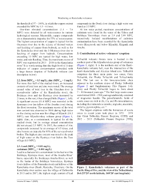
a large fissure eruption of Tolbachik volcano (see Kuril–Kamchatka and Aleutian Island arcs. Tolbachik
description below). comprises the three main parts: two cones, Ostry
Tolbachik, the Plosky Tolbachik and Tolbachinsky
2.2. Iron (MPC = 0.3 mg/L), zinc (MPC = 1 mg/L) Dol. The last one is the lava-pyroclastic plain
Zn
Fe
For more than half of the studied rivers, an increased adjacent to the southern slopes of Plosky Tolbachik
contents of total iron and zinc were noted. The average (Figure 2 and Supplementary File Figures 1-4).
annual value of total iron in the Uksichan river (a Ostry and Plosky Tolbachik began to form about
10
second-order inflow of the Kamchatka river), the 7 – 10 thousand years ago. The first large scoria cones
Bolshaya river and the Bystraya river increased by were formed 2000 – 1500 years ago and mainly consisted
2 times; in the rest, it has changed little (Figure 1, left). of magnesian basalts. The paleofumarolic fields of
A significant excess (11.4 MPC) was recorded in the scoria cones are rich in Zn, Cu, and Pb mineralization,
Krasnaya river (an inflow of the Avacha river) during including their minerals as tenorite, anglesite, atacamite,
the flood recession. The maximum excess of the total antlerite, pyromorphite, etc. 11
iron content was observed in 2014 during high water The largest eruptions with the formation of scoria
on the closing section near the village of Klyuchi (18.2 cones in recent years took place in 1975 – 1976
MPC), near Klyuchevskoy volcano group (Figure 1, (the Great Tolbachik Fissure Eruption, GTFE) and
right). Zinc, as a contaminant, is typical for all the 2012 – 2013 (Tolbachik Fissure Eruption [TFE],
studied rivers, but its average annual concentration
did not exceed 2.3 MPC. In 2015, the content of zinc
compounds increased by an average of 8.5 times, and
zinc became an impurity for 80% of the surveyed water
bodies. The highest zinc content was noted at the peak
of high water on the Bystraya river below the Esso
village (6.8 MPC).
2.3. Lead (MPC = 0.01 mg/L),
Pb
cadmium (MPC = 0.001 mg/L)
Cd
Lead is a characteristic contaminant for the basins of the
Bolshaya, Bystraya rivers, most of the Avacha River’
basin, especially the Srednyaya Avacha River, as well
as the basins of the Bolshaya Vorovskaya, Bystraya
rivers (inflow of the Paratunka river) and inflows of the
Kamchatka river (Bersh, Kavycha, Uksichan). On the Figure 2. Kamchatka’s volcanoes as part of the
Kamchatka river section near the village of Dolinovka Pacific Ring of Fire, and the view of the Tolbachinsky
in 2015 and in 2017, the highest single content of lead Dol (55°20’ north latitude, 160°20’ east longitude)
Volume 22 Issue 1 (2025) 35 doi: 10.36922/ajwep.8113