
Page 41 - JCAU-5-3
P. 41
Journal of Chinese
Architecture and Urbanism Walkability evaluation of Beijing Old Town
In this study, winter streetscape research was used as much
as possible to accurately express the effect of street physical
framework on walking experience, and walking comfort
can be improved by street green vision rate. In terms of
the esthetic perception of the street, within the buffer zone
of the Central Axis under World Heritage Site application,
the historic traditional style is an important feature that
shows the quality of the street. However, in addition to
the complete protection of the Central Axis Heritage
Area and the Historic District for tourism development,
there are still many historic buildings with inadequate
protection. Therefore, the Beijing Central Axis Protection
and Management Plan (2022-2035) should be regarded
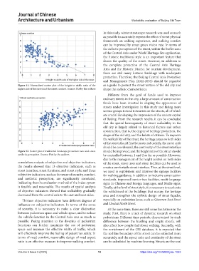
Figure 11. Normalized scatter plot of the height to width ratio of the as a guide to protect the street texture of the old city and
higher side of the street and the street comfort. Source: Plot by the authors shape the stylistic characteristics.
Different from the goal of funds used to improve
ordinary streets in the city, a large amount of construction
funds have been invested in shaping the appearance of
streets under investigation in this study and hiring more
service groups to tend to tourists on the streets, all of which
are crucial for shaping the impression of the ancient capital
of Beijing. From the research results, it can be concluded
that the spatial heterogeneity of street walkability in the
old city is largely related to historical factors and urban
construction, that is, the degree of heritage protection, the
shape of the old city, and the habits of citizens. To improve
the walkability of the street, the heritage areas on both sides
of the street should first be protected orderly, the street style
should be coordinated, the continuity of the street interface
Figure 12. Scatter plot of traditional landscape protection ratio and street should be improved, and the height ratio of the street should
aesthetic perception. Source: Plot by the authors be controlled between 1 and 2 as far as possible. However,
due to the management of the height control on both sides
correlation analysis of subjective and objective indicators, of the street, street trees and street facilities can be used to
the results showed that 13 objective indicators, such as create a comfortable street interface. Then, at the street level,
street interface, street furniture, and street style; and three we need to supplement and improve the signage facilities
subjective indicators, such as the sense of security, comfort, for walking guidance, in addition to inclusive construction
and aesthetic perception, are significantly correlated, standards, improved barrier-free facilities, multi-language
indicating that the evaluation method of the index system signs in Chinese and foreign languages, and Braille signs.
is feasible and reasonable. The results of spatial analysis Finally, at the level of street style, it is necessary to accelerate
of objective indicators showed that walkability gradually the withdrawal of the buildings that occupy the heritage
decreased from the central axis to the east and west sides. area and strengthen the stylistic design of street façades,
Thirteen objective indicators have different degrees of especially on pedestrian lanes, such as Qianmen East Street
influence on subjective indicators. In terms of the sense and Houhai North Street.
of security, it is necessary to make a clear distinction At the same time, there are still some limitations in the
between pedestrian space and vehicle space, and to reduce study. First, there is a lack of dynamic research on street
the vehicle function in the Central Axis area as much as pedestrians. Different time periods, characterized by stark
possible. Paying attention to the diversity of pedestrian difference between the bustling and empty streets, will
functions can further maximize the use of pedestrian also affect how people feel about walking. Secondly, with
space and increase the effective width of traffic, which the enrichment of the GIS database, it is expected that
will effectively improve the feeling of pedestrian safety. In the red line boundary of the street can be extracted more
terms of road comfort, reasonable design of road aspect accurately, and the aspect ratio and continuity of the street
ratio is an effective measure to improve walking comfort. can be calculated by machine learning. Streets are the soul
Volume 5 Issue 3 (2023) 10 https://doi.org/10.36922/jcau.1033