
Page 78 - JCAU-5-3
P. 78
Journal of Chinese
Architecture and Urbanism Spatial scale plasticity of urban residential areas
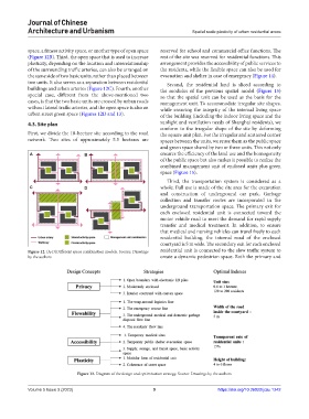
space, a fitness activity space, or another type of open space reserved for school and commercial office functions. The
(Figure 12B). Third, the open space that is used to increase rest of the site was reserved for residential functions. This
plasticity, depending on the location and interrelationship arrangement provides the accessibility of public services to
of the surrounding traffic arteries, can also be arranged on the residents, while the flexible space can also be used for
the same side of two basic units, rather than placed between evacuation and shelter in case of emergency (Figure 14).
two units. It also serves as a separation between residential Second, the residential land is sliced according to
buildings and urban arteries (Figure 12C). Fourth, another the modulus of the previous spatial model (Figure 15)
special case, different from the above-mentioned two so that the spatial unit can be used as the basis for the
cases, is that the two basic units are crossed by urban roads management unit. To accommodate irregular site shapes,
without lateral traffic arteries, and the open space is also an while ensuring the integrity of the internal living space
urban street green space (Figures 12D and 13). of the building (including the indoor living space and the
4.3. Site plan sunlight and ventilation needs of Shanghai residents), we
conform to the irregular shape of the site by deforming
First, we divide the 18-hectare site according to the road the square unit plan. For the irregular and scattered corner
network. Two sites of approximately 5.5 hectares are spaces between the units, we reuse them as the public space
and green space shared by two or three units. This not only
A B ensures the efficiency of the land use and the homogeneity
of the public space but also makes it possible to realize the
combined management unit of enclosed units plus green
space (Figure 15).
Third, the transportation system is considered as a
C D whole. Full use is made of the site area for the excavation
and construction of underground car park. Garbage
collection and transfer routes are incorporated in the
underground transportation space. The primary exit for
each enclosed residential unit is connected toward the
motor vehicle road to meet the demand for rapid supply
transfer and medical treatment. In addition, to ensure
that medical and nursing vehicles can travel freely to each
residential building, the internal road of the enclosed
courtyard is 5 m wide. The secondary exit for each enclosed
Figure 12. (A-D)Different space combination models. Source: Drawings residential unit is connected to the slow traffic system to
by the authors create a dynamic pedestrian space. Both the primary and
Figure 13. Diagram of the design and optimization strategy. Source: Drawings by the authors
Volume 5 Issue 3 (2023) 9 https://doi.org/10.36922/jcau.1242