
Page 22 - JCAU-5-4
P. 22
Journal of Chinese
Architecture and Urbanism Spatial morphology of cohesive village
A Dynasty government to establish the Maritime Silk Road,
and the relocation of Silk Road city from Guangzhou during
the Tang and Song dynasties to Quanzhou during the Ming
and Qing dynasties (Liu, 2002); and (iv) the banishment or
suspension of aristocratic officials (Jin, 2009). During this
period, the Putian people from Fujian province gradually
became the main population of the Leizhou Peninsula. In
addition, Zhejiang people adjacent to Fujian, Chaoshan
people, Guangfu people, Hakka people in Guangdong, and
Central Plains people in Henan, Jiangxi, and other areas
moved in with them (Cai, 1988; He, 1986; He, 2018; Liu,
B C 2015; Zhang, 1974). At this time, government control over
the Leizhou Peninsula gradually increased, and the clan
culture in the villages flourished exceptionally.
3.1. Spatial form of the village in line with the ideal
model of the clan
D E The spatial form of the cohesive village can meet the needs
of both single- and multiple-surname clans. For single-
surname clans, some of their villages are developed as fan-
shaped cohesion; some are divided into branches as the clan
population grows, reflected in the spatial form of the village;
some relatively independent “fans” will be formed that are
similar to the original texture but have a certain deviation;
and the ancestral hall of the branch is organized around
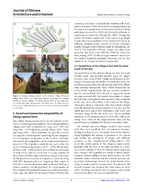
Figure 4. Storage–drainage system in the cohesive village (Xinpozai the large ancestral hall. This spatial relationship of villages
Village, Kelu Town). (A) Schematic diagram of storage and drainage derived from consanguinity takes ancestral halls or temples
system in cohesive village. (B) Water storage ditch of the main lane. as the core. Some place them in the center of the village;
(C) Residential water storage ditch. (D) Main lane. (E) Water pond in
front of the village during the dry season. Source: Drawing and photos others place them at road traffic hubs. The cohesive villages
by the author perfectly embody the strong cohesion of the clan, and the
highly geometric spatial form delineates a clear center and
3. Social environmental adaptability of boundary range for the life of the clan. The hierarchical
village spatial form expansion of the morphological structure also reflects the
strong ritual order of the single-surname clan, and the
The Leizhou Peninsula was used to be the land of Luo Yue, spatial hierarchy highlights the distinct hierarchical order.
which is vast and sparsely populated. The existing traditional
villages were built in between the Tang (618 – 907) and For multiple-surname villages, multiple clans restrict
Song (960 – 1279) dynasties, and the Ming (1368 – 1644) each other and coordinate their development. Resource
and Qing (1616 – 1911) dynasties, the periods in which sharing is its basic feature. The spatial form of the cohesive
the migration of immigrants caused significant changes in village highlights the sharing of resources to the utmost
the demographic composition of the Leizhou Peninsula. and satisfies the coexistence of people with different
The reasons for immigration can be summarized into four surnames in the “neighborhood” living pattern. First
aspects: (i) The migration caused by war, such as the end of all, the spatial pattern of the village is zoned clearly,
of the Southern Song dynasty (1127 – 1279), the invasion generally with the clan of the same surname in a zone.
of Yuan (1206 – 1368) soldiers, the southbound movement As a result, multiple similar fan-shaped spatial sequences
of Song family, and the movement of a large number of have emerged, with a spatial form similar to that of single-
Min people into the Leizhou Peninsula along the sea route; surname cohesive villages of clans and branches, but with
(ii) the government’s policy of migration, such as the Tang relatively weaker cohesion and less obvious primary and
(618–907) dynasty’s policy of “migrating Min people to secondary relationships. Second, the spatial layout of the
Hezhou” to consolidate border defense (former Hezhou is village is weakly centered or polycentric. The ancestral hall
today’s Leizhou); (iii) the migration of a large number of of each surname clan becomes the clan’s center, or other
Min people to the Leizhou Peninsula as a result of maritime public buildings and spaces such as squares and temples
trade, especially after the opening of Xuwen Port by Han serve to form their own cohesive spatial forms.
Volume 5 Issue 4 (2023) 4 https://doi.org/10.36922/jcau.1224