
Page 114 - JCAU-6-2
P. 114
Journal of Chinese
Architecture and Urbanism Development protection of ethnic villages
5.1.2. Enhancing the traffic system within the scenery reconstruct the traffic system within villages, emphasizing
of the village the role of slow traffic (Figure 20). Relying on the
construction of Jixiang Eternal Pagoda Site Park, the pagoda
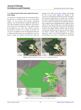
According to the functional orientation of Guantian Village, site wall will be transformed into a public space to display
the plan aims to delineate all types of land use indicators Tusi Culture, Buddhist pagoda historical images, ethnic art,
(Figure 19) and promote the landscape, agricultural and other contents. By making full use of the spatial pattern
landscape, and overall aesthetics through the renovation of and ecological resource background of the village, the plan
the living environment within the village area. This initiative seeks to link the original village ruins in the high mountains,
seeks to promote the development of rural global tourism enrich the tourists’ experience, and extend the stay time of
by leveraging the area’s open rural landscape resources. tourists in the village. Finally, a diverse array of content
Embracing the concepts of “one village, one product” and covering agricultural product production, mountain sports
“one scene, one industry” within the framework of the new and leisure activities, village sightseeing, and cultural
local theory, the plan endeavors to strengthen the connection experiences will be curated. This includes the creation of
between villages and national and provincial roads and special village scenes such as colorful flowers blanketing
Figure 18. Adjustment of land use in key areas. Source: Drawings by the authors
Figure 19. Village land use planning. Source: Drawing by the authors
Volume 6 Issue 2 (2024) 11 https://doi.org/10.36922/jcau.2043