
Page 105 - JCAU-6-3
P. 105
Journal of Chinese
Architecture and Urbanism Influence of land-use change on carbon storage
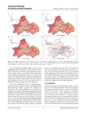
A B
C D
Figure 5. Spatial distribution pattern of carbon storage and carbon source (sink) in Chengdu from 2010 to 2020. (A) Spatial distribution pattern of
carbon storage in 2010. (B) Spatial distribution pattern of Carbon storage in 2015. (C) Spatial distribution pattern of carbon storage in 2020. (D) Spatial
distribution pattern of carbon sources (sinks) in 2000 – 2020. Source: Drawings by the authors
The carbon density of different land-use types varies showed a decreasing trend, with the characteristics of
significantly. Many studies have shown that the carbon “slow reduction first and then accelerated reduction” over
density of forests in Chengdu is higher than that of other time. The distribution of carbon source area presented
land-use types, followed by cultivated land, construction spatial aggregation. The northern and southern parts of
land, wetland, and unused land (Chuai et al., 2011). The the city were the primary carbon sources, with the eastern
conversion of land-use type can change the carbon density and county center as secondary carbon sources. This
of land. The transfer of high-carbon land to low-carbon pattern is consistent with the distribution characteristics of
land strengthens the influence of carbon sources, while the construction land increase and urban expansion.
opposite conversion enhances the carbon sink effect.
The urban development strategy of “Advancing East, 5. Conclusion
Expanding South, Controlling West, Reforming North, In the past decade, the comprehensive reform of urban
and Optimizing Middle” proposed by Chengdu has and rural areas characterized by “Three Concentration”
changed the city’s urban spatial layout. As the green axis has significantly influenced land-use patterns in Chengdu.
of the city, the vegetation of Longquan Mountain has been From 2010 to 2020, the net increase of construction
rapidly restored, contributing to approximately 42% of the land was 45,445.131 ha, while cultivated land decreased
total carbon storage in the city. This area can be used as by 44,100.596 ha. The conversion of cultivated land to
a priority protection area for carbon storage. The western construction land was mainly concentrated in the southern
part of the city is dominated by high-standard farmland part (15,572.62 ha), northern part (9,144.17 ha), and eastern
and ecological protection, while the eastern and southern part (14,774.51 ha), reflecting the impact of Chengdu’s
parts are the main expansion areas of urban construction. spatial development strategy on land-use patterns. The
From 2010 to 2020, the total carbon storage in Chengdu main reason for the decrease of carbon storage in Chengdu
Volume 6 Issue 3 (2024) 9 https://doi.org/10.36922/jcau.3069