
Page 43 - JCAU-6-3
P. 43
Journal of Chinese
Architecture and Urbanism Utilization of rural heritage
A B
C
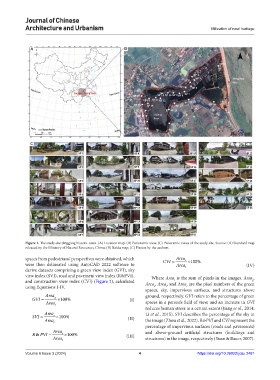
Figure 1. The study site: Jinggang historic town. (A) Location map. (B) Panoramic view. (C) Panoramic views of the study site. Source: (A) Standard map
released by the Ministry of Natural Resources, China; (B) Baidu map; (C) Photos by the authors
spaces from pedestrians’ perspectives were obtained, which CVI = Area c × 100%
were then delineated using AutoCAD 2022 software to Area (IV)
derive datasets comprising a green view index (GVI), sky t
view index (SVI), road and pavement view index (R&PVI), Where Area is the sum of pixels in the images. Area ,
t
and construction view index (CVI) (Figure 2), calculated Area , Area, and Area are the pixel numbers of the green
g
using Equations I-IV. s i c
spaces, sky, impervious surfaces, and structures above
Area ground, respectively. GVI refers to the percentage of green
GVI = g × 100% (I)
Area t spaces in a person’s field of view, and an increase in GVI
reduces human stress to a certain extent (Jiang et al., 2014;
Area Li et al., 2015). SVI describes the percentage of the sky in
SVI = s × 100% (II)
Area t the image (Zhou et al., 2022). R&PVI and CVI represent the
percentage of impervious surfaces (roads and pavements)
Area and above-ground artificial structures (buildings and
R & PVI = i × 100% (III)
Area t structures) in the image, respectively (Yuan & Bauer, 2007).
Volume 6 Issue 3 (2024) 4 https://doi.org/10.36922/jcau.2481