
Page 47 - JCAU-6-3
P. 47
Journal of Chinese
Architecture and Urbanism Utilization of rural heritage
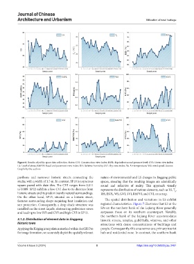
Figure 6. Results of public space data collection. Notes: CVI: Construction view index; ESPL: Equivalent sound pressure level; GVI: Green view index;
LS: Level of stress; R&PVI: Road and pavement view index; RH: Relative humidity; SVI: Sky view index; Ta: Air temperature; WS: wind speed. Source:
Graphs by the authors
pavilions and narrower historic streets connecting the nature of environmental and LS changes in Jinggang public
stacks, with a width of 1.5 m. In contrast, SP18 is a spacious spaces, ensuring that the resulting images are scientifically
square paved with slate tiles. The CVI ranges from 0.011 sound and reflective of reality. This approach visually
to 0.809. SP22 exhibits a low CVI due to its distance from represents the distribution of various elements, such as LS, T,
historic streets and its predominantly natural surroundings. RH, ESPL, WS, GVI, SVI, R&PVI, and CVI, on a map. a
On the other hand, SP13, situated on a historic street,
features surrounding shops requiring heat insulation and The spatial distribution and variations in LS exhibit
sun protection. Consequently, a deep shade structure was regional characteristics. Figure 7 illustrates that LS at the
installed on the street façade, obstructing pedestrian views SPs on the northern bank of the Lujiang River generally
and leading to low SVI and GVI and high CVI in SP13. surpasses those on its southern counterpart. Notably,
the northern bank of the Lujiang River accommodates
3.1.2. Distribution of element data in Jinggang historic streets, temples, guild halls, wharves, and other
historic town attractions with dense concentrations of buildings and
Applying the Kriging interpolation method within ArcGIS Pro people. Consequently, this area serves as a primary tourist
for image formation, we accurately depict the spatially relevant hub and residential zone. In contrast, the southern bank
Volume 6 Issue 3 (2024) 8 https://doi.org/10.36922/jcau.2481