
Page 60 - JCAU-6-4
P. 60
Journal of Chinese
Architecture and Urbanism Cultural heritage in monastic settlements
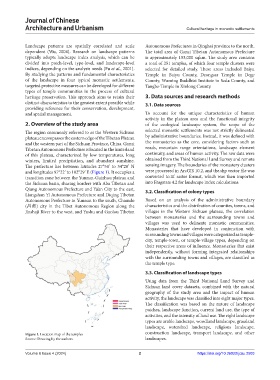
Landscape patterns are spatially correlated and scale Autonomous Prefectures in Qinghai province to the north.
dependent (Wu, 2004). Research on landscape patterns The total area of Ganzi Tibetan Autonomous Prefecture
typically adopts landscape index analysis, which can be is approximately 153,000 sqkm. The study area contains
divided into patch-level, type-level, and landscape-level a total of 251 temples, of which four temple clusters were
indices, depending on the analysis needs (Fu et al., 2001). selected for detailed study. These areas included Baiyu
By studying the patterns and fundamental characteristics Temple in Baiyu County, Dzongsar Temple in Dege
of the landscape in four typical monastic settlements, County, Wuming Buddhist Institute in Seda County, and
targeted protective measures can be developed for different Tangbo Temple in Xinlong County.
types of temple communities in the process of cultural
heritage preservation. This approach aims to retain their 3. Data sources and research methods
distinct characteristics to the greatest extent possible while 3.1. Data sources
providing reference for their conservation, development,
and spatial management. To account for the unique characteristics of human
activity in the plateau area and the functional integrity
2. Overview of the study area of the ecological landscape system, the scope of the
The region commonly referred to as the Western Sichuan selected monastic settlements was not strictly delineated
plateau encompasses the eastern edge of the Tibetan Plateau by administrative boundaries. Instead, it was defined with
and the western part of the Sichuan Province, China. Ganzi the monasteries as the core, considering factors such as
Tibetan Autonomous Prefecture is located in the hinterland roads, mountain range orientations, landscape element
of this plateau, characterized by low temperatures, long continuity, and areas of human activity. The raw data were
winters, limited precipitation, and abundant sunshine. obtained from the Third National Land Survey and remote
The prefecture lies between latitudes 27°58’ to 34°20’ N sensing imagery. The boundaries of the monastery clusters
and longitudes 97°22’ to 102°29’ E (Figure 1). It occupies a were processed in ArcGIS 10.2, and the.shp vector file was
transition zone between the Yunnan-Guizhou plateau and converted to.tif raster format, which was then imported
the Sichuan basin, sharing borders with Aba Tibetan and into Fragstats 4.2 for landscape index calculations.
Qiang Autonomous Prefecture and Ya’an City to the east, 3.2. Classification of colony types
Liangshan Yi Autonomous Prefecture and Diqing Tibetan
Autonomous Prefecture in Yunnan to the south, Chamdo Based on an analysis of the administrative boundary
(昌都) city in the Tibet Autonomous Region along the characteristics and the distribution of counties, towns, and
Jinshaji River to the west, and Yushu and Guolou Tibetan villages in the Western Sichuan plateau, the correlation
between monasteries and the surrounding towns and
villages was used to delineate monastic communities.
Monasteries that have developed in conjunction with
surrounding towns and villages were categorized as temple-
city, temple-town, or temple-village types, depending on
their respective areas of influence. Monasteries that exist
independently, without forming integrated relationships
with the surrounding towns and villages, are classified as
the temple type.
3.3. Classification of landscape types
Using data from the Third National Land Survey and
Sichuan land cover datasets, combined with the natural
geography of the study area and the impact of human
activity, the landscape was classified into eight major types.
The classification was based on the nature of landscape
patches, landscape function, current land use, the type of
activities, and the intensity of land use. The eight landscape
types are arable landscape, woodland landscape, grassland
landscape, watershed landscape, religious landscape,
Figure 1. Location map of the temples construction landscape, transport landscape, and other
Source: Drawing by the authors. landscapes.
Volume 6 Issue 4 (2024) 2 https://doi.org/10.36922/jcau.2503