
Page 74 - JCAU-6-4
P. 74
Journal of Chinese
Architecture and Urbanism Regeneration of Xinmalu, Ningbo
a bustling center for Chinese finance, trade, and
shipping enterprises. It became an important business
hub with a comfortable living environment. Xinmalu
Block emerged as residential quarters for Western
expatriates and affluent businessmen. The block
was marked by signs of modernity, particularly in
infrastructure and transportation. Xinmalu Road
was the first modern paved road in the city, and the
Yongcao Railway, also located within Xinmalu Block,
was the first railway in Ningbo.
(iii) The Decline (1949 – 1990): Plenty of eclectic-style
houses built during the late Qing dynasty remained
in the Jiang Bei An area. However, while the old
memories persisted in these historical buildings and
streets, the area began to experience a gradual decline.
(iv) The Transformations (1990 – 2022): Over the decades,
many historical buildings, streets, and infrastructures
suffered from a lack of maintenance, leading to
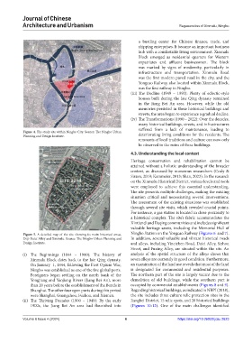
Figure 4. The study site within Ningbo City. Source: The Ningbo Urban
Planning and Design Institute. deteriorating living conditions for the residents. The
remnants of local traditions and culture can now only
be observed in the ruins of these buildings.
4.3. Understanding the local context
Heritage conservation and rehabilitation cannot be
attained without a holistic understanding of the broader
context, as discussed by numerous researchers (Cody &
Siravo, 2019; Kammeier, 2013; Shan, 2023). In the research
on the Xinmalu Historical District, various levels and tools
were employed to achieve this essential understanding.
The site presents multiple challenges, making the existing
situation critical and necessitating several interventions.
The assessment of the existing situations was established
through several site visits, which revealed crucial points.
For instance, a gas station is located in close proximity to
a historical complex. The site’s fabric accommodates the
Xintiandi and Daqing communities and includes significant
valuable heritage assets, including the Memorial Hall of
Figure 5. A detailed map of the site showing its main historical areas, Ningbo Station on the Yongcao Railway (Figures 6 and 7).
Deji-Daici Alley and Xinmalu. Source: The Ningbo Urban Planning and In addition, several valuable and vibrant historical roads
Design Institute. and alleys, including Yincizhen Road, Daici Alley, Sizhou
Street, and Fuxing Alley, are situated within the site. An
(i) The Beginnings (1844 – 1900): The history of analysis of the spatial structure of the alleys shows that
Xinmalu Block dates back to the late Qing dynasty. seven alleys are currently in good condition. Furthermore,
On January 1, 1844, following the First Opium War, an examination of the land use reveals that most of the land
Ningbo was established as one of the five global ports. is designated for commercial and residential purposes.
Foreigners began settling on the north bank of the The northern part of the site is largely vacant due to the
Yongjiang and Yaojiang Rivers (Jiang Bei An), more demolition of old buildings, while the southern part is
than 20 years before the establishment of the Bunds in occupied by commercial establishments (Figures 8 and 9).
Shanghai. The other four open ports during this period Regarding historical buildings, as indicated in NBPI (2018),
were Shanghai, Guangzhou, Fuzhou, and Xiamen. the site includes three culture relic protection sites in the
(ii) The Thriving Decades (1900 – 1949): By the early Jiangbei District, 15 relic spots, and 28 historical buildings
1900s, the Jiang Bei An area had flourished into (Figures 10-12). One of the main challenges identified
Volume 6 Issue 4 (2024) 6 https://doi.org/10.36922/jcau.2623