
Page 76 - JCAU-6-4
P. 76
Journal of Chinese
Architecture and Urbanism Regeneration of Xinmalu, Ningbo
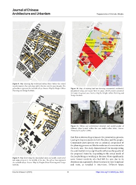
Figure 8. Map showing the traditional urban fabric before the radical
transformations that took place within the site over the past decades. The
yellow lines represent the walkable alleys. Source: Map by Ningbo Urban Figure 10. Map of existing land use showing commercial, residential,
Planning and Design Institute. educational areas, and vacant land (in gray), which presents potential
for future integrated uses. Source: Map by Ningbo Urban Planning and
Design Institute.
Figure 11. Urban and architectural structure and spatial quality of
different alleys located within the case study’s urban fabric. Source:
Photos by the author (2018).
that this understanding enhances the preservation process,
leading to improvements in both the place and the people.
Community participation was an essential component of
the planning process and the formulation of a new vision for
the study area. The study demonstrated that incorporating
the community’s voice significantly enhances the quality of
the proposed vision by responding to the actual needs of
the people living or working in the area. More significantly,
Figure 9. Map illustrating the demolished areas and newly constructed some former residents who had left the area due to its
real estate projects in the middle of the site. The yellow lines represent
the walkable alleys. Source: Map by Ningbo Urban Planning and Design deterioration expressed a desire to return to their homeland
Institute. and roots, as revealed in interviews. Different future
Volume 6 Issue 4 (2024) 8 https://doi.org/10.36922/jcau.2623