
Page 58 - JCAU-7-3
P. 58
Journal of Chinese
Architecture and Urbanism Rural–urban village regeneration
Table 1. Village dynamics on land ownership, regulations, and governance
Intricate land ownership Unspecific regulations Loose governance
Perceived trespassing of adjacent Inaccurate survey of a permanent private structure as temporary No governance over the integrity of the
private land property being in the informal squatter structures landscape, replacing the village’s esthetics
same in-between backyard space with standard forms of a “Spanish villa”
Overlapping of building footprints Statutory assessment of restoration works using the Uncoordinated development turning
and land boundaries due to inaccurate development-oriented framework of SHP historic structures with shared components
land survey into eclectic and eccentric hybrids
Unaware of trespassing issues due to Architectural work is highly limited to restoring the old as the old,
the inaccessibility of land records albeit the change of building volumes due to inaccurate land surveys
The inflexible land policy that forbids small-scale activities at
restored village houses, resulting in the lengthy statutory submission
for the change of land use from “House” to “Shop and services” and
the additional fire services installations under the urban standards
Abbreviation: SHP: Small House Policy.
Table 2. Discrepancies between actual and expected realities
Aspects Expected outcome Actual reality
Role of villagers As partners for collaborations As employees under the University
Remuneration A reasonable rate mutually agreed upon A standard pay scale assessed by academic experience
between the research team and villagers
Hierarchical power relation Villagers and researchers as collaborators Villagers as landowner clients;
Researchers as service providers
Incentives Historical and cultural values Monetary compensation as one of the primary motivations
Perception toward the research team An effective collaborator Not-so-trusted outsider
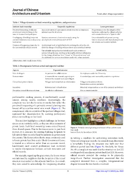
performative cooking process, it inadvertently caused
tension among nearby residents. Interestingly, the
complaint was not due to noise or smoke but rather the
perceived trespassing of a privately owned planting area
fenced off by a yellow metal wire mesh (Figure 8). The
complainant, who is a relative of the partner villager chef,
expressed her dissatisfaction by warning participants
about encroaching on her land.
This incident highlights a critical challenge: in-between
spaces are not entirely public, as they are often remnants of
private lands. Such land ownership issues extend beyond
these shared spaces. Due to the inaccuracies in past land Figure 8. Privately owned planting area fenced off by a yellow metal
wire mesh
surveys, it is common for existing building footprints to Source: Photo by the authors (2020).
fall outside their recorded land boundaries in government
documents. The demarcation district map, commonly used in writing a condition for authorizing restoration work.
to locate private land lots under Block Government Lease, Upon retrieving land records, the research team discovered
is treated as a reference rather than an accurate record. a remarkable finding: the structure was built over four
Landowners must consult professional land surveyors different partial land lots (Figure 9). Similarly, for House
to resolve discrepancies between as-built structures and No. 49, a complaint was made that the structure on Lot 222
official records. overlapped with an adjacent private land (Lot 223). However,
For example, regarding the grain store, the house owner official records revealed the overlap to be physically
was informed by neighbors that the footprint of the ruined insignificant. Further investigation uncovered that the
structure encroached on the adjacent land lots. As a result, complaint stemmed from a complex, intergenerational
they were asked to acknowledge the trespassing situation dispute between the two families involved.
Volume 7 Issue 3 (2025) 9 https://doi.org/10.36922/jcau.4992