
Page 75 - {PDF Title}
P. 75
Water quality and health risks
insights for enhancing water safety and public health in The region’s subsurface geology is primarily composed
Kushtia Municipality. of unconsolidated sediments, such as sand and clay,
forming shallow and deep aquifers that serve as the
2. Materials and methods municipality’s primary groundwater sources. The depth
of groundwater typically ranges from 1 to 3 m, indicating
2.1. Study area a high water table that is particularly susceptible to
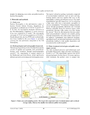
Kushtia Municipality is the administrative center of external contamination. Groundwater recharge primarily
26
Kushtia District, Khulna Division, Bangladesh. Its occurs through precipitation infiltration and riverbank
geographical coordinates are 23°54’10” N and 89°7’9” filtration, especially during the monsoon season, while
E. In 2011, the municipality (formerly referred to as groundwater discharge helps sustain river flow during
the Old Municipality) comprised 12 wards; however, dry periods. However, the interaction between surface
27
it has since expanded to 21 wards. The municipality water and groundwater is dynamic and complex, posing
23
now spans 42.79 km and has a population of 226,800. potential contamination risks when surface water sources
24
2
Despite this growth, only four WTPs and overhead tanks are polluted. Contaminants from industrial discharge,
have been installed in the area (Figure 1), primarily agricultural runoff, and untreated wastewater can infiltrate
covering the area previously designated as the Old groundwater, leading to water quality degradation and
Municipality. associated public health hazards. 28
2.2. Hydrogeological and hydrographic framework 2.3. Water treatment technologies and public water
The hydrogeological framework of Kushtia Municipality supply systems
consists of aquifers and aquitards, with groundwater- The water treatment processes and technologies used
bearing zones identified through hydrostratigraphic in Kushtia Municipality align with those described by
analysis. The municipality is situated adjacent to Fayshal et al. The municipality operates four WTPs
25
29
the Madhumati and Gorai Rivers, which significantly designed primarily for the removal of arsenic and iron.
influence groundwater recharge and discharge processes. After treatment, the purified water is pumped into
Figure 1. Study area and sampling points. The larger dots represent water treatment plants and overhead
storage tanks, whereas the smaller dots indicate public water points.
Volume 22 Issue 1 (2025) 69 doi: 10.36922/ajwep.8163