
Page 34 - JCAU-5-3
P. 34
Journal of Chinese
Architecture and Urbanism Walkability evaluation of Beijing Old Town
for World Heritage List, the volume of modern residential
buildings and commercial buildings in the Southern
district of the city and the Eastern and Western districts
of the city within the Second Ring Road is very different
from that of the historic district, thus it is not included in
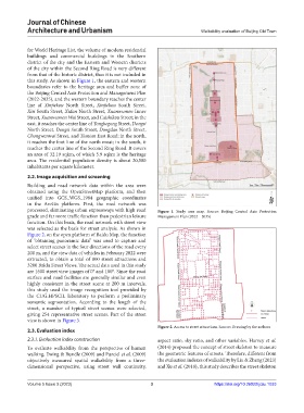
this study. As shown in Figure 1, the eastern and western
boundaries refer to the heritage area and buffer zone of
the Beijing Central Axis Protection and Management Plan
(2022-2035), and the western boundary reaches the center
line of Xinjiekou North Street, Xinjiekou South Street,
Xisi South Street, Xidan North Street, Xuanwumen Inner
Street, Xuanwumen Wai Street, and Caishikou Street; in the
east, it reaches the center line of Yonghegong Street, Dongsi
North Street, Dongsi South Street, Dongdan North Street,
Chongwenwai Street, and Tiantan East Road; in the north,
it reaches the foot line of the north moat; in the south, it
reaches the center line of the Second Ring Road. It covers
an area of 32.19 sqkm, of which 5.9 sqkm is the heritage
area. The residential population density is about 20,500
inhabitants per square kilometer.
2.2. Image acquisition and screening
Building and road network data within the area were
obtained using the OpenStreetMap platform, and then
unified into GCS_WGS_1984 geographic coordinates
in the ArcGis platform. First, the road network was
processed, eliminating urban expressways with high road Figure 1. Study area map. Source: Beijing Central Axis Protection
grade and far more traffic function than pedestrian leisure Management Plan (2022 – 2035)
function. On this basis, the road network with street view
was selected as the basis for street analysis. As shown in
Figure 2, on the open platform of Baidu Map, the function
of “obtaining panoramic data” was used to capture and
select street scenes in the four directions of the road every
200 m, and the view data of vehicles in February 2022 were
extracted, to obtain a total of 800 street attractions and
3200 Baidu Street Views. The actual data used in this study
are 1600 street view images of 0° and 180°. Since the road
surface and road facilities are generally similar and even
highly consistent in the street scene at 200 m intervals,
this study used the image recognition tool provided by
the CUG.HPSCIL laboratory to perform a preliminary
semantic segmentation. According to the length of the
street, a number of typical street scenes were selected,
giving 254 representative street scenes. Part of the street
view is shown in Figure 3.
Figure 2. Access to street attractions. Source: Drawing by the authors
2.3. Evaluation index
2.3.1. Evaluation index construction aspect ratio, sky ratio, and other variables. Harvey et al.
To evaluate walkability from the perspective of human (2014) proposed the concept of street skeleton to measure
walking, Ewing & Rundle (2009) and Purciel et al. (2009) the geometric features of streets. Therefore, different from
objectively measured spatial walkability from a three- the evaluation indexes of walkability by Liu & Zheng (2023)
dimensional perspective, using street wall continuity, and Xu et al. (2018), this study describes the street skeleton
Volume 5 Issue 3 (2023) 3 https://doi.org/10.36922/jcau.1033