
Page 67 - JCAU-6-4
P. 67
Journal of Chinese
Architecture and Urbanism Cultural heritage in monastic settlements
routes, with the temple built as an independent structure on fragmentation. Dzongsar Monastery has the highest SHDI
the mountain, and the monks’ residences are constructed in (0.97), demonstrating balanced patch distribution and
harmony with the temple. diverse land use, while Wuming Buddhist Institute has a
lower SHDI (0.64), reflecting patch unbalance and more
5.2. Landscape-level analysis of monastic limited land use, likely due to the specialized nature of its
settlements function. This analysis shows that the functional role of a
The landscape patterns of four typical monastic monastery significantly affects land use diversity around
settlements were analyzed at the landscape level, as shown the settlement. Monasteries with more comprehensive
in Table 5. The area-weighted average patchwork fractal functions encourage people to live in accordance with the
index of the monastic settlement reflects the overall monastery, while those with specialized functions limit
complexity of the monastic settlement. This suggests the development of the surrounding land. The geographic
that the natural landscape in the monastic settlement and human factors involved in choosing the location of a
experiences minimal interference from human activities. monastery are mutually influential, but the functions of the
Tangbo Temple, a typical temple-village settlement, monastery ultimately play a decisive role in determining
has the highest fractal index (11.47), indicating a more the location of the monastery.
complex landscape structure. This complexity is associated The AI of the monastery clusters is above 95%, indicating
with the combination of the village and the monastery. that the landscape patches are highly aggregated. Regarding
In contrast, monastic settlements that form alongside the spreading index (CONTAG), the values are as follows:
towns show less complexity, which indicates that human Wuming Buddhist College (81.08) > Baiyu Temple (78.07)
activity and the creation of artificial landscapes reduce > Tangbo Temple (77.57) > Dzongsar Temple (73.24). In
landscape complexity. The increase in the formation of general, the dominant patches of each temple cluster display
anthropogenic landscapes correlates with a decrease good continuity, suggesting that the development of the
in complexity, supporting the division of monastic temple as the core exhibits strong spatial expansion potential.
settlements into different types. The LSI characterizes the
shape of patches within the landscape. A higher LSI value An analysis of the landscape patterns and surrounding
indicates greater separation between patches. The highest land of each monastic settlement, based on the settlement
degree of separation is observed at Tangbo Temple, further type, reveals that woodland and grassland landscapes
illustrating that the separation of patches in monastic occupy a substantial proportion of the land around the
settlements is inextricably linked to the settlement type. settlement. This finding suggests that monastic settlements
require specific landscape features: grassland for grazing,
The SHEI values for the settlements are as follows:
Dzongsar Temple (0.47) > Tangbo Temple (0.38) > water sources for providing drinking water for monks
and local residents, forested areas for supplying timber
Baiyu Temple (0.35) > Wuming Buddhist College (0.33).
However, all values are below 0.5, indicating that these for construction and firewood, stone materials for making
landscapes are dominated by only a few land-use types. millstones and building houses, and land for construction
Through the analysis of each settlement, it becomes and cultivation (Longzhu, 2016).
clear that forest, grassland, and arable landscapes are the In summary, the landscape patterns of the four typical
dominant types, emphasizing the importance of geographic monastic settlements reflect the significant influence of a
factors in the formation of monastic settlements. The monastery’s positioning and location on its surrounding
SHDI reflects the heterogeneity of landscapes in each landscape. The in-depth analysis of various indicators
settlement. A higher SHDI value in a complete landscape offers a clearer understanding of the formation of the
system indicates richer land use and a higher degree of landscape pattern in these settlements.
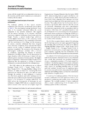
Table 5. Landscape‑level indices for each monastic settlement
No. Name of temple Overall indicators Shape indicator Diversity Convergence and
indicators divergence indicator
NP TA (ha) AWMPFD LSI SHEI SHDI AI (%) CONTAG (%)
1 Baiyu Temple 920 3,674.25 9.27 11.27 0.35 0.72 95.72 78.07
2 Dzongsar Temple 745 8,964.48 6.86 11.33 0.47 0.97 97.23 73.24
3 Tangbo Temple 1,702 8,603.01 11.47 15.56 0.38 0.79 97.21 77.57
4 Wuming Buddhist College 1,390 7,055.83 8.10 10.23 0.33 0.64 98.00 81.08
Abbreviations: SHEI: Shannon’s evenness index; TA: Total landscape area; LSI: Landscape shape index; CONTAG: Contagion index.
Volume 6 Issue 4 (2024) 9 https://doi.org/10.36922/jcau.2503