
Page 91 - JCAU-6-4
P. 91
Journal of Chinese
Architecture and Urbanism Village spatial form and activation
village runs parallel to the ridgeline, and buildings are buildings. They serve as gathering places for villagers’
grouped along contour lines on both sides, with branching daily interaction and are generally semi-open spaces
alleys extending from the central axis of the ridgeline. enclosed on one or four sides.
Darongpo new village features semi-open spaces bordered (iii) Narrow alleys: These alleys are about 0.8 – 1.2 m
by slopes and buildings, with evenly distributed large wide and designed primarily for pedestrian traffic.
structures along contour lines on one or both sides of the In densely built villages, these alleys appear as closed
road. Although the main roads are spacious, some streets spaces, while in villages with a relatively sparse
and alleys are narrow, creating spatial scale issues. architectural layout, they appear as unenclosed alleys.
Wangjia village and Zaige new village have a linear In terms of street dimensions, the street depth-
distribution along a contour line, with relatively narrow height ratio of different villages can be divided into three
streets and lanes. Buildings in Wangjia village are sparse, types (Table 1). As the depth-height ratio of the street
resulting in weak spatial aggregation. In addition, in is <1, visibility within the space significantly reduces,
mountainous villages with radiation-type streets, the diminishing attention to building heights. The reduced
street connection mode presents three-dimensional street light levels create a darker and more confined
characteristics: main streets parallel the mountain contour atmosphere. As 1≤ depth-height ratio ≤2, the visible sky
lines, while branch lanes connect in oblique “Z” or “H” area reduces, shifting attention to the surrounding walls.
shapes. This three-dimensional connection allows the This ratio provides a strong sense of spatial definition
main street and branch lane to ascend gradually along the within the street. As the depth-height ratio is ≥4, a
contour line, facilitating the development of the whole larger visible sky area is allowed, weakening the spatial
village on the mountainside. definition of the street. This is the largest proportion of
(b) Enclosure form of typical street spaces street space; however, if the ratio exceeds 4, the space can
feel excessively empty.
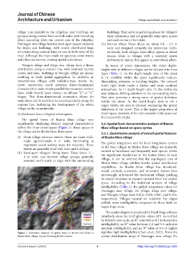
The spatial forms of Biasha Miao village vary
significantly, displaying distinct regional characteristics 3.2. Spatial form characteristics analysis of Biasha
within the inner street spaces (Figure 7). Street spaces in Miao village based on space syntax
the village can be divided into three types:
3.2.1. Quantitative analysis of overall spatial features
(i) Open village entrance streets: These are main traffic of Biasha Miao village
roads approximately 6 m wide, functioning as The global integration and R3 local integration centers
important social activity areas for residents. These of the four villages in Biasha Miao village are primarily
streets are generally lined with trees and buildings.
(ii) Semi-open villagers’ living lanes: These lanes, 3 – located in functional and frequently used spaces. Given
the significant similarities in the spatial fabric of each
4 m wide, run between village groups, generally village, it can be inferred that the topological core of
oriented north-south to align with the surrounding
Biasha Miao village exhibits similar spatial distribution
capabilities. As Biasha Miao village has developed,
social, cultural, economic, and structural factors have
increasingly influenced the traditional village, pushing
its overall structure to expand outward from the central
space. According to the statistical analysis of village
intelligibility (Table 2), the global integration values for
Darongpo new village, Da village, Zaige new village,
and Wangjia village were 0.472, 0.506, 0.047, and 0.514,
respectively. Villages located on relatively flat slopes
exhibit lower intelligibility compared to those built on
larger slope areas.
The scatter diagrams produced by DepthMap software
intuitively show the intelligibility values (R ). As verified
2
by Hillier’s case study, an R² value below 0.2 indicates low
intelligibility; an R² value between 0.2 and 0.4 indicates
medium intelligibility; and an R² value of 0.4 or higher
Figure 7. Schematic diagram of spatial types of streets and alleys in signifies high intelligibility (Chen et al., 2022). From the
Biasha Miao village. Source: Drawing by the authors. scatter distribution maps of Darongpo new village, Da
Volume 6 Issue 4 (2024) 9 https://doi.org/10.36922/jcau.2502