
Page 94 - JCAU-6-4
P. 94
Journal of Chinese
Architecture and Urbanism Village spatial form and activation
A B A B
C D
C D
E F
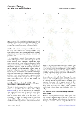
Figure 10. Axis map of the average depth of each Biasha Miao village. (A)
Mean depth axis chart of Darongpo new village. (B) Mean depth axis chart
of Da village. (C) Mean depth axis chart of Zaige new village. (D) Mean
depth axis chart of Wangjia village. Source: Drawings by the authors.
vehicles and humans, serving as distribution centers
for village traffic and the most densely populated living G H
areas. The decreasing integration values toward the village
edges indicate a corresponding reduction in vehicle and
pedestrian flow.
A comprehensive analysis of the connection, average
depth, and integration values of the street spaces of each
village reveals a strong correlation between the street
space layout and the overall village configuration. In Da
village’s zonal distribution and Wangjia village’s group Figure 11. Comparison of global integration and local integration values
distribution, the main streets are generally well-defined. of R3 in each village. (A) Global integration of Darongpo new village.
In the naturally evolved mountain villages, such as (B) R3 local integration of Darongpo new village. (C) Global integration
Zaige new village and Darongpo new village, the street of Da village. (D) R3 local integration of Da village. (E) Global integration
spaces adapt to the mountain terrain without forming a of Zaige new village. (F) R3 local integration of Zaige new village.
prominent street. Regardless of the village type, the streets (G) Global integration of Wangjia village. (H) R3 local integration of
Wangjia village. Source: Drawings by the authors.
and lanes in the central areas exhibit high accessibility
and connectivity, enabling villagers to easily access public developed nodes within each village. These high-flow areas
areas, thus enhancing the quality of life, leisure, and serve not only as daily living spaces for villagers but also
entertainment. as important distribution spaces within the village. They
represent the streets with the highest capacity for flow
3.2.3. Quantitative analysis of point-like public space distribution in Biasha Miao village, connecting the main
characteristics in Biasha Miao village
scenic spots and architectural clusters. These areas play
Through the simulation analysis of visual area integration vital roles in cultural display and distribution within the
values and pedestrian flow in Biasha Miao village village.
(Figures 12 and 13), it can be seen that the core integration
value is generally located near the geometric center of the 3.3. Research on the activation strategy of Biasha
village. Public spaces are predominantly located either Miao village
near the village’s main roads, which offer good traffic Based on the comprehensive analysis of the spatial form
accessibility, or within the central geometric area of the characteristics of Biasha Miao village, the current study
village. All four villages exhibit densely populated areas, addresses site challenges and optimizes spatial structure
and the areas with high pedestrian traffic are found in well- through a landscape activation design that focuses on
Volume 6 Issue 4 (2024) 12 https://doi.org/10.36922/jcau.2502