
Page 95 - JCAU-6-4
P. 95
Journal of Chinese
Architecture and Urbanism Village spatial form and activation
A B A B
C D C D
E F
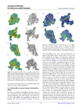
Figure 13. Simulation analysis of pedestrian flow in each village.
(A) Crowd streamline simulation analysis of Darongpo new village.
(A) Crowd streamline simulation analysis of Da village. (A) Crowd
streamline simulation analysis of Zaige new village. (A) Crowd streamline
simulation analysis of Wangjia village. Source: Drawings by the authors.
The surrounding street areas were interconnected to
G H improve the overall system configuration of the spatial
road network in the region. A comparative analysis of
the integration degree of the newly planned and original
street networks (Figure 16) showed that the formation
of the new road network significantly improves the road
integration value of the central area of the village core, thus
providing a more concentrated space for the flow of people
and objects in the entire street network in the village. After
reconstruction, Da village, located along the main road,
serves as an important road axis that can drive economic
Figure 12. Comparative analysis of visual integration values of each development in Biasha Miao village. The new roads with
village. (A) Sight integration analysis of Darongpo new village. (B) Present higher accessibility foster closer interactions between the
situation pattern of Darongbo village. (C) Sight integration analysis of Da core area of Da village and the divergence axis, guiding
village. (D) Present situation pattern of Da village. (E) Sight integration
analysis of Zaige new village. (F) Present situation pattern of Zaige new future redesign of the spatial structure and embedding
village. (G) Sight integration analysis of Wangjia village. (H) Present of functional units. The road networks among the four
situation pattern of Wangjia village. Source: Drawings by the authors. villages are densely developed, and areas with the highest
integration and depth values are typically found in zones
three aspects: road improvement, street depth-height ratio with the most concentrated architectural layouts. This
control, and space node optimization. arrangement significantly improves the regional utilization
rate of Biasha Miao village’s core area, enhances overall
3.3.1. Road traffic activation strategy in Biasha Miao functionality, and boosts accessibility, thereby attracting
village more visitors. By improving the integration rate of the
To further strengthen the guiding development effect of village’s street network, closer connections between the
the central area on the surrounding spaces and effectively core and surrounding spaces are achieved, enabling the
manage pedestrian flow, the existing road network in smoother diversion of pedestrian flow from the core to
the four main villages was expanded according to the other spaces. Consequently, the reconstruction has greatly
existing road network conditions (Figures 14 and 15). enhanced street accessibility. Analysis of accessibility and
Volume 6 Issue 4 (2024) 13 https://doi.org/10.36922/jcau.2502