
Page 98 - JCAU-6-4
P. 98
Journal of Chinese
Architecture and Urbanism Village spatial form and activation
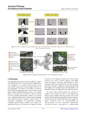
Figure 17. Schematic diagram of the spatial depth-height ratio of streets and alleys in Biasha Miao village. Note: D/H: Depth-height ratio.
Source: Drawings by the authors.
Figure 18. Detailed design plan of each village node. Source: Drawings by the authors.
4. Discussion protection and development planning. The current study
integrates field survey manual mapping with digital
The geographical limitations of some traditional villages, spatial information technology, demonstrating a multi-
especially those located in complex terrains and landforms, technology integration approach for protection planning
pose challenges in accurately capturing their spatial and activation design of traditional villages, thus providing
environment using remote sensing images that focus on new insights into the digitalization, informatization, and
macrogeographic information. Low-altitude unmanned scientific planning of village protection and development.
aerial vehicle mapping images offer a solution by providing
high-resolution, detailed features and data on the village’s The space syntax model quantitatively explores the
spatial environment. These images are characterized by complex spatial features formed by self-organization,
real-time capability, high efficiency, and low cost, making abstracting the complex street space system into an axis
them a valuable supplement to remote sensing technology model that clearly and intuitively reflects spatial connections.
and traditional manual mapping methods. With the At the same time, quantitative indicators such as integration
continuous development of information technology, degree, connection value, and comprehensibility are
diversified spatial analysis methods and models will used to directly reflect the composition characteristics
significantly improve the refinement of traditional village of settlement spaces, aiding planners in understanding
Volume 6 Issue 4 (2024) 16 https://doi.org/10.36922/jcau.2502