
Page 97 - JCAU-6-2
P. 97
Journal of Chinese
Architecture and Urbanism Residential urban heritage space study
Table 1. (Continued)
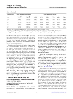
Space subsystem Spatial topological relationship index Spatial material structure index
Int.VR 1000 Int.VR 5000 ADE SME FME HE RE PDE
YZ9 117.7827 3160.3264 0.0359 6.7167 2.3423 0.7737 0.9681 6.6892
YZ10 87.8204 2817.8822 0.0401 6.5057 0.4857 0.5946 0.7219 6.1996
YZ11 96.1079 2814.3358 0.0502 5.7796 0.9837 0.8061 0.8454 5.8043
YZ12 120.3480 3248.3679 0.0510 5.6561 2.7648 0.9951 0.8302 5.3034
YZ13 83.9771 2852.0998 0.0471 5.6668 1.6673 0.6124 0.9921 5.4651
YZ14 91.9263 3022.6343 0.0440 4.1699 0.9475 0.9911 1.4399 3.9477
YZ15 57.6069 2758.8220 0.0545 4.5744 0.0000 1.1853 1.3433 4.4104
Note: In the table, a value of “0.000” indicates that the feature attributes for the specified region are identical.
Abbreviations: ADE: Architectural density entropy; FME: Function mixing entropy; HE: Heritage space entropy; Int.VR 1000 : Life Integration;
Int.VR : Global Integration; PDE: Population density entropy; RE: Residential entropy; SME: Spatial morphology entropy.
5000
the difference in the impact of Life Integration and Global crucial to accurately categorize spaces to understand their
Integration on material structure is relatively small, mainly composition and value. To achieve this goal, this study
affecting the northeast-southwest axis of “Uji Bridge Road- proposes a classification model based on spatial clustering
Byodo-in Front Approach,” indicating a “unidirectional methods, combined with dendrogram and cubic clustering
permeation” from the exterior to the interior with minimal criterion analysis. This approach enables the division of
internal impact and permeation. the residential urban heritage spaces of Suzhou’s Pingjiang
Regarding the influence of individual building structures Historic District and Uji City’s Nakauji District into seven
on material distribution, the traditional courtyards in different categories. Through this classification model, the
the Pingjiang Historic District remain enclosed and are historical value of different areas can be clearly identified,
less likely to be developed into commercial spaces along thereby providing more accurate theoretical support for
the street. Their larger scale also implies that changes the in-depth protection and value excavation of residential
predominantly occur in a block-distributed manner within urban heritage spaces.
the site. In addition, the winding alleys between courtyards During the analysis, spatial topology indicators such
create a “resistance effect” to external resources, thereby as Life Integration and Global Integration are combined
stabilizing spatial entropy and preserving the authenticity with spatial material structure indicators, including ADE,
and integrity of residential spaces. In the Nakauji District, SME, FME, HE, RE, and PDE. The aim is to perform
the traditional Japanese “Machiya” buildings, with their spatial clustering on the sub-spaces within the study area,
front-shop-back-residence model, limit the availability of emphasizing architectural cluster zones and focusing on
functional spaces for external capital. Material changes both the material flow structure and material distribution
mainly occur along the main roads, thus maintaining the structure of heritage spaces. The clustering results are
overall integrity and stability of population entropy and depicted in Figure 5A and B.
residential space entropy within the living spaces. However,
larger “Machiya” are often subdivided to accommodate Based on the cluster distance tree of spatial subsystems
more businesses and achieve higher architectural within the research area and the application of the cubic
returns, resulting in a more uniform distribution of high- clustering criterion, combined with on-site survey data and
density, low-area building clusters along the main roads, expert assessments, three modern commercial areas (PJ14,
consequently reducing the ADE. PJ17, and PJ22) located in the Pingjiang Historic District
were excluded from further consideration. Subsequently,
5. Identification, demarcation, and the heritage spaces were divided into seven categories to
potential assessment model for residential facilitate the potential assessment of residential heritage
urban heritage spaces spaces. These categories take into consideration various
aspects, such as current regional status, development
5.1. Identification and assessment of residential status, and heritage potential. They encompass the Core
urban heritage spaces Historical Heritage Preservation Area, Core Historical
When studying the identification and potential Heritage Development and Commercial Integration
determination of residential urban heritage spaces, it is Zone, Residential Historical Heritage Potential Zone,
Volume 6 Issue 2 (2024) 11 https://doi.org/10.36922/jcau.1732