
Page 93 - JCAU-6-2
P. 93
Journal of Chinese
Architecture and Urbanism Residential urban heritage space study
A B
Figure 2. Spatial subsystem segmentation map of the research site. (A) Schematic diagram of spatial subsystems in Pingjiang historic district. (B) Schematic
diagram of spatial subsystems in Nakauji district. Source: Drawings by the authors
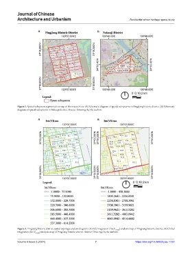
A B
Figure 3. Pingjiang historic district spatial topology analysis diagram. (A) Life integration (Int.V R1000 ) analysis map of Pingjiang historic district. (B) Global
integration (Int.V R5000 ) analysis map of Pingjiang historic district. Source: Drawings by the authors
Volume 6 Issue 2 (2024) 7 https://doi.org/10.36922/jcau.1732