
Page 31 - JCAU-6-3
P. 31
Journal of Chinese
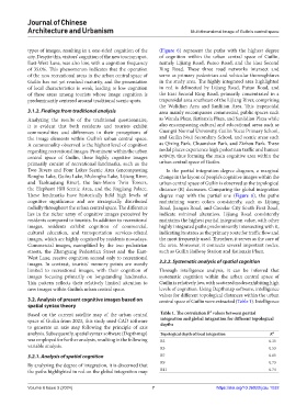
Architecture and Urbanism Multidimensional image of Guilin’s central space
types of images, resulting in a one-sided cognition of the (Figure 6) represent the paths with the highest degree
city. Despite this, visitors’ cognition of the new tourism spot, of cognition within the urban central space of Guilin,
East-West Lane, was also low, with a cognition frequency namely Lijiang Road, Putuo Road, and the East Second
of 35.0%. This phenomenon indicates that the operation Ring Road. These three road networks intersect and
of the new recreational areas in the urban central space of serve as primary pedestrian and vehicular thoroughfares
Guilin has not yet reached maturity, and the presentation in the study area. The highly integrated area highlighted
of local characteristics is weak, leading to low cognition in red is delineated by Lijiang Road, Putuo Road, and
of these areas among tourists whose image cognition is the East Second Ring Road, primarily concentrated in a
predominantly centered around traditional scenic spots. trapezoidal area southeast of the Lijiang River, comprising
the Wulidian Area and Sanlitian Area. This trapezoidal
3.1.2. Findings from traditional analysis area mainly encompasses commercial, public spaces such
Analyzing the results of the traditional questionnaire, as Wanda Plaza, Jiatianxia Plaza, and Sanlidian Plaza while
it is evident that both residents and tourists exhibit also encompassing cultural and educational areas such as
commonalities and differences in their perceptions of Guangxi Normal University, Guilin Yucai Primary School,
the image elements within Guilin’s urban central space. and Guilin No.1 Secondary School, and scenic areas such
A commonality observed is the highest level of cognition as Qixing Park, Chuanshan Park, and Zizhou Park. These
regarding recreational images. Prominent within the urban nodal places experience high pedestrian traffic and human
central space of Guilin, these highly cognitive images activity, thus forming the main cognitive area within the
primarily consist of recreational landmarks, such as the urban central space of Guilin.
Two Rivers and Four Lakes Scenic Area (encompassing In the partial integration degree diagram, a marginal
Ronghu Lake, Guihu Lake, Mulonghu Lake, Lijiang River, change in the layout of people’s cognitive images within the
and Taohuajiang River), the Sun-Moon Twin Towers, urban central space of Guilin is observed as the topological
the Elephant Hill Scenic Area, and the Jingjiang Palace. distance (R) decreases. Comparing the global integration
These landmarks have historically held high levels of degree map with the partial one (Figure 6), the paths
cognitive significance and are strategically distributed maintaining warm colors consistently, such as Lijiang
radially throughout the urban central space. The difference Road, Jiangan Road, and Circular City South First Road,
lies in the richer array of cognitive images perceived by indicate minimal alteration. Lijiang Road consistently
residents compared to tourists. In addition to recreational maintains the highest partial integration value, with other
images, residents exhibit cognition of commercial, highly integrated paths predominantly intersecting with it,
cultural education, and transportation services-related indicating its status as the primary route for traffic flow and
images, which are highly cognized by residents nowadays. the most frequently used. Therefore, it serves as the core of
Commercial images, exemplified by the two pedestrian the area. Moreover, it connects several important nodes,
streets, the Zhengyang Pedestrian Street and the East- such as Guilin Railway Station and Jiatianxia Plaza.
West Lane, receive cognition second only to recreational
images. In contrast, tourists’ memory points are mostly 3.2.2. Systematic analysis of spatial cognition
limited to recreational images, with their cognition of Through intelligence analysis, it can be inferred that
images focusing primarily on longstanding landmarks. systematic cognition within the urban central space of
This pattern reflects their relatively limited attention to Guilin is relatively low, with scattered nodes exhibiting high
new images within Guilin’s urban central space. levels of cognition. Using Depthmap software, intelligence
values for different topological distances within the urban
3.2. Analysis of present cognitive images based on central space of Guilin were extracted (Table 1). Intelligence
spatial syntax theory
Based on the current satellite map of the urban central Table 1. The correlation R² values between partial
space of Guilin from 2023, this study used CAD software integration and global integration for different topological
depths
to generate an axis map following the principle of axis
analysis. Subsequently, spatial syntax software (Depthmap) Topological depth of local integration R²
was employed for further analysis, resulting in the following R3 0.35
variable analysis. R5 0.53
3.2.1. Analysis of spatial cognition R7 0.65
By analyzing the degree of integration, it is discerned that R9 0.73
the paths highlighted in red on the global integration map R11 0.74
Volume 6 Issue 3 (2024) 7 https://doi.org/10.36922/jcau.1032