
Page 32 - JCAU-6-3
P. 32
Journal of Chinese
Architecture and Urbanism Multidimensional image of Guilin’s central space
A B
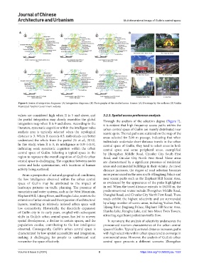
Figure 6. Series of integration diagrams. (A) Integration diagrams. (B) Photographs of the studied areas. Source: (A) Drawings by the authors; (B) Guilin
Municipal People’s Government website
values are considered high when R is 5 and above, and 3.2.3. Spatial access preference analysis
the partial integration map closely resembles the global Through the analysis of the selection degree (Figure 7),
integration map when R is 9 and above. According to the it is evident that high-frequency access paths within the
literature, systematic cognition within the intelligent value urban central space of Guilin are mainly distributed near
analysis area is typically selected when the topological scenic spots. The red paths are scattered on the map of the
distance is 3. When R exceeds 0.5, individuals can better areas selected for 5,00 m passage, indicating that when
understand the whole from the partial (Li et al., 2010). individuals undertake short-distance travels in the urban
In this study, when R is 3, its intelligence is 0.35 (<0.5), central space of Guilin, they tend to select areas in both
indicating weak systematic cognition within the urban central space and some peripheral areas, exemplified
central space of Guilin. Selecting a typical space in the by Zhongshan Middle Road, Circular City South First
region to represent the overall cognition of Guilin’s urban Road, and Circular City North First Road. These areas
central space is challenging. The cognition between nodes are characterized by a significant presence of residential
varies and lacks systemization, with locations of human areas and commercial buildings in their vicinity. As travel
activity being scattered. distance increases, the degree of road selection becomes
From a perspective of natural geographical conditions, more pronounced in the area south of Jingjiang Palace and
the low intelligence observed within the urban central near scenic parks such as the Elephant Hill Scenic Area,
space of Guilin may be attributed to the impact of as evidenced by the appearance of the paths highlighted
landscape patterns on traffic planning. The presence of in red. When the travel distance extends to 10,000 m, the
mountains and water systems, such as the West Mountain, predominant red routes include Zhongshan Middle Road,
Elephant Hill, Lijiang River, and Ronghu Lake, restricts the Shanghai Road, and Circular City North First Road. These
extension of urban roads and the expansion of architectural roads exhibit the highest selectivity and are surrounded
layouts, resulting in relatively isolated urban space with by a large number of scenic areas, including Yushan Park,
low connectivity. Historically, the disorderly expansion Lijiang River, Jingjiang Palace, Elephant Hill Scenic Area,
of Guilin city in its early years, coupled with subsequent Shanhu Lake, Ronghu Lake, and Sun-Moon Twin Towers,
shifts in Guilin’s urban central space, has led to uneven attracting significant pedestrian traffic flow.
spatial development, a decline in certain spaces, and the In summary, the analysis of selectivity underscores the
population exodus, contributing to the low intelligence pronounced tourism characteristics of the urban central
observed. Consequently, Guilin’s urban central space is space of Guilin. Typically, as travel distance increases, paths
characterized by low spatial accessibility and integration, with high selectivity within urban space tend to converge in
making it challenging for people to understand and commercial areas. However, the analysis of Guilin’s urban
remember the space effectively. central space presents a different scenario. Zhongshan
Volume 6 Issue 3 (2024) 8 https://doi.org/10.36922/jcau.1032