
Page 33 - JCAU-6-3
P. 33
Journal of Chinese
Architecture and Urbanism Multidimensional image of Guilin’s central space
A B
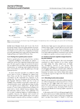
Figure 7. Series selection map. (A) Selection maps. (B) Photographs of the studied areas. Source: (A) Drawings by the authors; (B) Guilin Municipal
People’s Government website
Middle Road, Shanghai Road, and Circular City North distribution of high cognitive areas and poor connectivity
First Road emerge as the main paths preferred by people. between urban images. As travel distance increases, there
Notably, the common feature of the land use surrounding is a noticeable shift in people’s chosen destinations from
these highly selective paths is their designation for tourism commercial to recreational areas. This trend likely stems
purposes, particularly scenic spots, including Yushan Park, from better traffic accessibility in recreational areas, leading
Jingjiang Palace, and Elephant Hill Scenic Area. to a heightened cognitive tendency toward such locales.
3.2.4. Findings from spatial syntax research 3.3. Analysis of present cognitive images based on
big data methods
Based on spatial syntax theory, using the three variables
– integration, intelligence, and selection for analysis – a In the realm of big data research, this study thoroughly
conclusion can be drawn regarding Guilin’s urban central considered the image cognition of two distinct groups
space: the main cognitive images are recreational in nature; of people within the urban central space of Guilin.
they are isolated from each other, each possessing distinct The investigation centered on two primary data
characteristics, yet exhibiting weak overall systematicity, platforms: microblogging and travelogue platforms. The
and a limited ability to cognize the global space through microblogging data platform, predominantly utilized by
partial perspective. local residents, and the travelogue data platform, primarily
In essence, the most cognizable area within the urban frequented by tourists, were used as distinct data sources
central space of Guilin is delineated by Lijiang Road, to examine the cognitive images within the urban central
Putuo Road, and the East Second Ring Road, mainly space of Guilin.
concentrated in the trapezoidal area southeast of the 3.3.1. Microblog location data analysis
Lijiang River. This area encompasses the Wulidian Fruit
and Vegetable Wholesale Market and the vicinity of Sina Microblog (hereinafter referred to as Weibo) stands as
Sanlidian Plaza, featuring recreational, commercial, and one of the most popular social media platforms in China,
cultural education venues – public places at large. Notably, boasting over 224 million daily active users as of the
the core cognitive area is Lijiang Road – Shanghai Road, end of 2022, with mobile users accounting for over 90%.
serving as a nexus connecting prominent landmarks and Given its widespread usage, leveraging Weibo location
nodes such as Guilin Railway Station, Jiatianxia Plaza, data proves invaluable for studying people’s cognition of
and Chuanshan Primary School. Here, pedestrian flow various spots.
is at its peak, facilitating heightened understanding and In this study, a total of 462 microblogs geotagged within
recognition. However, the intricate road network and the urban central space of Guilin and posted on the Weibo
numerous transitions within Guilin’s urban central space platform over a span of 4 days (comprising 2 working days
diminish spatial comprehensibility, resulting in a scattered and 2 rest days) from March 9 to March 12, 2023 were
Volume 6 Issue 3 (2024) 9 https://doi.org/10.36922/jcau.1032