
Page 140 - JCAU-7-2
P. 140
Journal of Chinese
Architecture and Urbanism Urban features of PRD in online image
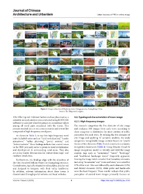
Figure 3. Image collection of Machong town, Dongguan city, Guangdong, China
Source: The Bing search engine.
After filtering out irrelevant factors such as place names, a 4.2. Typological characteristics of town image
semantic network analysis was conducted using ROSTCM6 4.2.1. High-frequency images
software to calculate word frequency co-occurrence values
among all word pairs associated with the towns. This The research categorizes the five elements of city image
process resulted in a co-occurrence matrix and a word list and evaluates 100 images from each town according to
composed of high-frequency word pairs. these categories to determine the main content of public
As shown in Table 2, to top five high-frequency word perception for each town. By refining the five elements of
pairs included terms such as “rural revitalization,” “tourist city image and applying AI semantic analysis, the study
attractions,” “valley planning,” “portal website,” and categorizes recognizable image content based on Lynch’s
“district website.” These findings indicate that central towns theory of five elements (Table 3) and constructs a semantic
in the PRD primarily serve to promote rural revitalization recognition framework (Table 4). Using Tencent Cloud AI
and development in surrounding rural areas. They also image recognition model to identify and label the image
act as key tourist destinations for visitors from large- and content, tags such as “mountains,” “water,” “buildings,”
medium-sized cities. and “traditional landscape towns” frequently appeared.
Furthermore, the findings align with the objectives of Scoring the image labels revealed that boundary elements,
the One Hundred Million Project in Guangdong province. including “mountains” and “rivers and lakes,” accounted for
Central towns, typically situated in valley plains, are planned 37% of the total. This was followed by node elements (14%)
and designed to integrate with their valley landforms. and district elements (11%), while paths and landmarks
In addition, relevant information about these towns is were the least frequent. These results indicate that public
disseminated through portal websites and local websites. perception of central town images primarily focuses on
Volume 7 Issue 2 (2025) 6 https://doi.org/10.36922/jcau.5733