
Page 154 - JCAU-7-2
P. 154
Journal of Chinese
Architecture and Urbanism Tracing Minyue Kingdom’s roads with LCP
3. Restoring Minyue Kingdom’s road of Fujian province (Figure 2) to investigate its historical
networks context within the Minyue Kingdom.
3.1. Survey site and research period Regarded as the “Southeast Mountain Kingdom,”
Fujian province stands as a geographically distinct region
Drawing on historical atlases and relevant documents, the within China. Its terrain, defined by prominent water
Minyue Kingdom is identified as a regional power that ridges, divides the province into unique physiognomic and
emerged during the Western Han dynasty (202 BCE – 8 CE), hydrological units, with the exception of the Ting river.
centered in what is now Fujian province in southeastern Notably, all rivers in Fujian originate within its borders
China. The temporal scope of this study spans the Qin and flow toward the sea along the provincial shoreline. The
dynasty (221 – 206 BCE) to the Eastern Han dynasty region’s tallest ridge, the highest in southeastern mainland
(25 – 220), delineating the chronological boundaries of the China, forms a natural barrier that shields Fujian from
Minyue Kingdom. northern cold fronts, contributing to its unique climatic
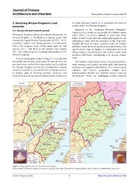
Ancient cartographic evidence (Figure 1) indicates that traits.
during the Qin dynasty, particularly the period when the The intricate relationship between Fujian’s landforms,
area was known as the Minzhong county, and throughout water systems, and climate has profoundly influenced its
the Minyue Kingdom period, the administrative domain soil types and vegetation distribution. This environmental
extended beyond the current borders of Fujian province cohesion and relative geographic stability have
to include parts of Zhejiang province. However, this simultaneously limited and fostered Fujian’s historical
research focuses on the modern administrative boundaries development. While the challenging terrain restricted
Figure 1. The geographical extent of the Minyue Kingdom
Source: Modified historical map by the authors, originally from State Cultural Relics Bureau (2009), Atlas of Chinese Cultural Relics, Fujian Rite.
Volume 7 Issue 2 (2025) 4 https://doi.org/10.36922/jcau.4226