
Page 159 - JCAU-7-2
P. 159
Journal of Chinese
Architecture and Urbanism Tracing Minyue Kingdom’s roads with LCP
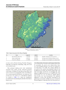
Figure 5. Cost grid surface of ancient roads
Source: Drawing by the authors.
Table 3. Important passes of the Minyue Kingdom
No. Name Longitude Latitude Location
1. Wuyi Mountain Water Pass 117.837738 27.936084 Wuyishan, Nanping city, Fujian province
2. Ziling Pass in Pucheng 118.626321 28.236052 Pucheng county, Nanping city, Fujian province
3. Pukui Pass in Zhangpu 117.460064 24.059252 Zhangpu county, Zhangzhou city, Fujian province
city sites, such as Fuzhou Yecheng, Wuyishan Chengcun, 3.4.4. Restoration of ancient road transportation lines
Hancheng, and Jianyang Datancheng, along with seven To reconstruct the ancient road transportation lines,
critical ancient roads. the “Cost Weighted Distance” function was deployed in
Nine principal starting points were meticulously the final phase of the study. This involved utilizing the
cataloged using county records. Advanced geospatial key nodes of the ancient roads identified earlier as the
technologies, including API and Xgeocoding (which were foundational source data. The analysis integrated the “Cost
Path” tool within ArcGIS Pro 3.2, leveraging the point
used to decode ancient geographic names and determine database established in Section 3.4.3. In addition, the “cost
their precise longitude and latitude), were employed. This backtracking link” and “cost distance” outputs derived
process led to the creation of a comprehensive database from Section 3.4.2 were incorporated. The combined
(as detailed in Tables 3-5), laying the foundational application of these tools and data culminated in the
groundwork for reconstructing the network of the Minyue generation of the ancient road lines that once traversed the
ancient roads. Minyue Kingdom occupying present-day Fujian province.
Volume 7 Issue 2 (2025) 9 https://doi.org/10.36922/jcau.4226