
Page 157 - JCAU-7-2
P. 157
Journal of Chinese
Architecture and Urbanism Tracing Minyue Kingdom’s roads with LCP
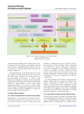
Figure 3. Technical route for the restoration of the Minyue Kingdom
Source: Drawing by the authors.
Abbreviation: LCP: Least-cost path.
site points and the attributes of the resistance base surface. radiometric calibration process to modify the spectral
D represents the spatial distance traversed by an ancient characteristics of land boundary classes, enhancing
ij
road site across a geographical base surface i from the the interpretative quality. Subsequent atmospheric
starting point j to a specific point in space, while Ri is the correction was applied to remove radiative distortions
resistance coefficient. caused by atmospheric conditions, thereby retrieving
accurate surface reflectance of terrestrial objects. The
The implementation of the MCR model was carried strategic combination of different bands was employed
out using the Cost Path tool in ArcGIS Pro 3.2 software. to facilitate the extraction of vegetation and land use
The MCR model prioritizes the environmental and classifications.
geomorphological characteristics of ancient roads,
incorporating multiple cost weights into the computation For the classification of land types, a non-parametric
to generate an optimal path. This approach is particularly method coupled with an unsupervised approach was
effective for spatial analysis in areas with complex selected. Considering the extensive area of the study,
topographical features. As a result, it provides robust land use in Fujian province was categorized into four
technical support for analyzing the ancient roads of Fujian classes based on the land use status classification standard
province during the Minyue Kingdom era, taking into (GB/T21010-2017): vegetation, water bodies, constructed
account a range of influencing factors. land, and unused land. These classifications are visually
represented in Figure 4 and detailed in Table 1.
3.4. Restoration procedure
3.4.2. Generation of comprehensive resistance value
3.4.1. Envi5.3 interpretation of remote sensing images
The delineation of ancient road routes is intricately linked
Utilizing Envi5.3, Landsat 8 remote sensing data (2014 – to the geographical environment. To simulate the ancient
2018) with a resolution of 30 m and cloud cover <1% were terrain, archaeologists and scientists often utilize modern
accessed for the summer season. The data underwent a landform data. In determining the resistance factors
Volume 7 Issue 2 (2025) 7 https://doi.org/10.36922/jcau.4226