
Page 158 - JCAU-7-2
P. 158
Journal of Chinese
Architecture and Urbanism Tracing Minyue Kingdom’s roads with LCP
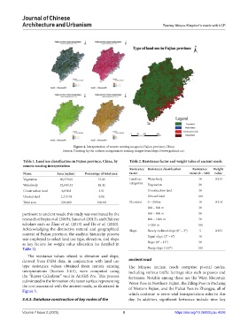
Figure 4. Interpretation of remote sensing images in Fujian province, China
Source: Drawing by the authors using remote sensing images from https://www.gscloud.cn/.
Table 1. Land use classification in Fujian province, China, by Table 2. Resistance factor and weight value of ancient roads
remote sensing interpretation
Resistance Resistance classification Resistance Weight
Name Area (sq km) Percentage of total area factor value (0 – 100) value
Vegetation 90,579.65 73.05 Land use Waterbody 10 0.533
categories
Waterbody 22,844.53 18.42 Vegetation 20
Construction land 6,836.8 5.51 Construction land 30
Unused land 1,215.78 0.98 Unused land 100
Total area 124,000 100.00 Elevation 0 – 200 m 10 0.214
200 – 500 m 30
pertinent to ancient roads, this study was motivated by the 500 – 800 m 50
research of Beyin et al. (2019), San et al. (2013), and Chinese 800 – 1200 m 70
scholars such as Zhao et al. (2013) and Hu et al. (2020). >1200 m 100
Acknowledging the distinctive natural and geographical Slope Slowly inclined slope (0° – 3°) 5 0.253
context of Fujian province, the analytic hierarchy process Equal slope (3° – 8°) 10
was employed to select land use type, elevation, and slope
as key factors for weight value allocation (as detailed in Slope (8° – 15°) 30
Table 2). Sharp slope (>25°) 100
The resistance values related to elevation and slope,
derived from DEM data, in conjunction with land use ancient road
type resistance values obtained from remote sensing The Minyue ancient roads comprise pivotal nodes,
interpretations (Section 3.4.1), were computed using including various traffic heritage sites such as passes and
the “Raster Calculator” tool in ArcGIS Pro. This process fortresses. Notable among these are the Wuyi Mountain
culminated in the formation of a raster surface representing Water Pass in Northern Fujian, the Ziling Pass in Pucheng
the cost associated with the ancient roads, as illustrated in of Western Fujian, and the Pukui Pass in Zhangpu, all of
Figure 5.
which continue to serve vital transportation roles to this
3.4.3. Database construction of key nodes of the day. In addition, significant fortresses include nine key
Volume 7 Issue 2 (2025) 8 https://doi.org/10.36922/jcau.4226