
Page 89 - AJWEP-22-5
P. 89
Evaluation of riverbank water suitability
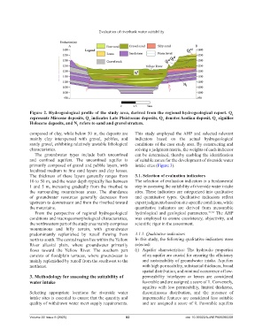
Figure 2. Hydrogeological profile of the study area, derived from the regional hydrogeological report. Q
1
represents Miocene deposits, Q indicates Late Pleistocene deposits, Q denotes Aeolian deposit, Q signifies
2
Holocene deposits, and N refers to sand and gravel stratum. 3 4
1
composed of clay, while below 50 m, the deposits are This study employed the AHP and selected relevant
mainly clay interspersed with gravel, pebbles, and indicators based on the actual hydrogeological
sandy gravel, exhibiting relatively unstable lithological conditions of the case study area. By constructing and
characteristics. solving a judgment matrix, the weights of each indicator
The groundwater types include both unconfined can be determined, thereby enabling the identification
and confined aquifers. The unconfined aquifer is of suitable zones for the development of riverside water
primarily composed of gravel and pebble layers, with intake sites (Figure 3).
localized medium to fine sand layers and clay lenses.
The thickness of these layers generally ranges from 3.1. Selection of evaluation indicators
10 to 50 m, and the water depth typically lies between The selection of evaluation indicators is a fundamental
1 and 5 m, increasing gradually from the riverbed to step in assessing the suitability of riverside water intake
the surrounding mountainous areas. The abundance sites. These indicators are categorized into qualitative
of groundwater resources generally decreases from and quantitative types. Qualitative indicators reflect
upstream to downstream and from the riverbed toward expert judgments based on site-specific conditions, while
the mountains. quantitative indicators are derived from measurable
From the perspective of regional hydrogeological hydrological and geological parameters. 31,32 The AHP
conditions and macrogeomorphological characteristics, was employed to ensure consistency, objectivity, and
the northwestern part of the study area mainly comprises scientific rigor in the assessment.
mountainous and hilly terrain, with groundwater
predominantly replenished by runoff flowing from 3.1.1. Qualitative indicators
north to south. The central region lies within the Yellow In this study, the following qualitative indicators were
River alluvial plain, where groundwater primarily selected:
flows toward the Yellow River. The southern part (i) Aquifer characteristics: The hydraulic properties
consists of floodplain terraces, where groundwater is of an aquifer are crucial for ensuring the efficiency
mainly replenished by runoff from the southwest to the and sustainability of groundwater intake. Aquifers
northeast. with high permeability, substantial thickness, broad
spatial distribution, and minimal occurrence of low-
3. Methodology for assessing the suitability of permeability interlayers or lenses are considered
water intake favorable and are assigned a score of 1. Conversely,
aquifers with low permeability, limited thickness,
Selecting appropriate locations for riverside water discontinuous distribution, and the presence of
intake sites is essential to ensure that the quantity and impermeable features are considered less suitable
quality of withdrawn water meet supply requirements. and are assigned a score of 0. Favorable aquifers
Volume 22 Issue 5 (2025) 83 doi: 10.36922/AJWEP025260208