
Page 218 - AJWEP-22-6
P. 218
Hao
Cloud-free or minimally clouded scenes covering Standard pre-processing steps, including radiometric
HCMC for the years 1988, 1995, 2002, 2010, 2017, and calibration, were performed. For the Landsat 7 ETM+
2024 were acquired from the United States Geological image acquired after the scan line corrector failure in
Survey Earth Explorer portal. Detailed information on May 2003, a gap-filling technique using local histogram
21
the acquired imagery is presented in Table 1. matching was applied to correct data gaps. Vector data
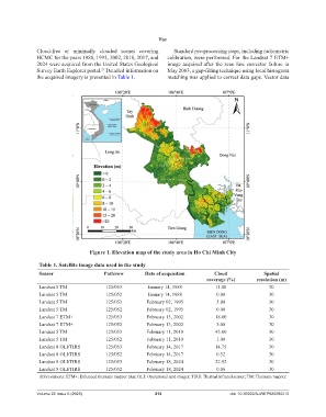
Figure 1. Elevation map of the study area in Ho Chi Minh City
Table 1. Satellite image data used in the study
Sensor Path/row Date of acquisition Cloud Spatial
coverage (%) resolution (m)
Landsat 5 TM 125/053 January 14, 1988 11.00 30
Landsat 5 TM 125/052 January 14, 1988 0.00 30
Landsat 5 TM 125/053 February 02, 1995 5.00 30
Landsat 5 TM 125/052 February 02, 1995 0.00 30
Landsat 7 ETM+ 125/053 February 13, 2002 18.00 30
Landsat 7 ETM+ 125/052 February 13, 2002 5.00 30
Landsat 5 TM 125/053 February 11, 2010 43.00 30
Landsat 5 TM 125/052 February 11, 2010 1.00 30
Landsat 8 OLI/TIRS 125/053 February 14, 2017 14.75 30
Landsat 8 OLI/TIRS 125/052 February 14, 2017 0.52 30
Landsat 8 OLI/TIRS 125/053 February 18, 2024 22.92 30
Landsat 8 OLI/TIRS 125/052 February 18, 2024 0.06 30
Abbreviations: ETM+: Enhanced thematic mapper plus; OLI: Operational land imager; TIRS: Thermal infrared sensor; TM: Thematic mapper.
Volume 22 Issue 6 (2025) 212 doi: 10.36922/AJWEP025260210